













![[Day 2] 14 Days Free Live Training on Geophysical Data Analysis](https://i.ytimg.com/vi/q0YcjOKs8yg/maxresdefault.jpg)


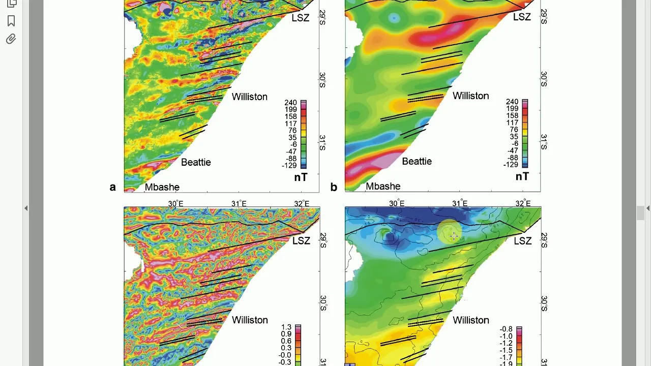





Magnetic surveys measure variations in the Earth's magnetic field to detect subsurface geological structures, utilizing different platforms (land, airborne, marine) and instruments (proton precession, flux gate, optically pumped magnetometers) to acquire data, followed by essential corrections including diurnal variation and IGRF (International Geomagnetic Reference Field) to isolate crustal anomalies, with interpretation involving both qualitative analysis of anomaly shapes and quantitative methods to estimate depth, size, and magnetization of subsurface bodies.
Magnetic Survey: Principles, Data Acquisition, Corrections & Interpretation
Added:Basic physics of electromagnetism, including magnetic fields, magnetic flux, and the characteristics of the Earth's geomagnetic field (declination, inclination, and diurnal variation).
Fundamental geological concepts, specifically the concept of magnetic susceptibility and how different rock types (igneous, metamorphic, and sedimentary) exhibit distinct magnetic properties.
The distinction between induced magnetization (temporary alignment in the Earth's current field) and remnant magnetization (permanent historical magnetic alignment in rocks).
Basic principles of spatial data collection and signal processing, such as spatial sampling intervals, grid interpolation, and signal-to-noise ratios.
Advanced quantitative interpretation and mathematical modeling of magnetic anomalies, including 2D and 3D magnetic inversion techniques.
Depth-to-source estimation methods for magnetic anomalies, such as Euler deconvolution, Werner deconvolution, and spectral analysis.
Integration of magnetic survey data with other geophysical methods (e.g., gravity, electromagnetics, and seismics) for joint inversion and geological mapping.
Applied magnetic prospecting for specialized industries, such as mineral exploration, archaeological site mapping, environmental hazard detection, and unexploded ordnance (UXO) clearing.
16.1K views260likes35:28Original Release: 2020-12-30
hello everyone so in my last lecture i have talked about the pointing vector and for the last few lectures i have talked about some maxwell's equation and its physical significances above all and you must remember that i have already discussed about the magnetic survey the sources of the magnetic field the power spectrum but uh really i don't have detail i have not given you the details about the survey the magnetic survey how it has been done actually in the real field that means now i am entering in this chapter as a pure geophysicist i am just showing you how the magnetic survey can be done in different platform means the magnetic data processing connection and interpretations itself a big thing so maybe in one lecture it cannot be covered still i will just give you some glimpse about that data acquisition data correction data processing and the qualitative the quantitative interpretation details about the magnetometer the designs these two are the magnetometers how the magnetic field uh how the can be echoed and magnetic data can be acquired so this is the shipboard survey pictorial defection and i will talk about also the magnetometers how the magnetic data can be acquired so let's move so first i will tell you a little bit about the magnetic field the magnetic field can be done from the different platforms land marine and the airborne survey with using the sensor they're called magnetometers so you must have remembered that totally the external field and the internal field is the main field is called so-called internal field the contribution from the external field up is two percent around is from the ionosphere solar radiation and the main field is all about the field generator in the outer core the motion of the liquid in the outer core the local field is the variation caused by the local magnetic anomaly in the earth crust so there are many magnetometers one is scalar magnetometer one is vector magnetometer so proton present magnetometer it just measures the total magnetic field so it is called the scalar magnetometer and there is another magnetometer optically pumped this is also a scalar magnetometer there is a vector magnetometer it measures the component of the magnetic field in a particular direction either h or y or z this is called the flux gate magnetometer so depending on the platform the magnetic survey can be of different type first we are having ground magnetic survey so suppose you target a smaller area in some defined targets called a particular mineralization so you carry out the ground magnetic survey yes you can cover big areas but for that airborne geophase is airborne magnetic service more suitable and there is a heliborne survey ex it explores the natural resources then we are having air magnetic aeromagnetic survey it this is for the reconnaissance large scale survey and marine magnetic service is also a large scale oceanographic surveying with a petroleum such okay it involves the measurement of the long wavelength that is coming from the lower crust in the upper metal it is a deep this is the large dip serving that's why you are getting long wavelength okay so what is our objective of generally magnetic measurement generally magnetic service carried out to estimate the depth of the basement that's what are the sedimentary sequences are there different formations are there yes gravity survey is also done but to know about the details magnetic surveys more it is a more complex survey than the gravity survey so you have to do first gravity surveying then thereafter followed by the magnetic survey so like that it's also used groundwater investigation mineral and hydrocarbon like gravity survey the pollution study so detailed interpretation of the total field magnetic survey we can also use this survey for oil and mineral research and the hazardous waste so but if you are doing the survey it requires proper filtering so you are having the raw data but without proper filtering and without doing the diagnostic procedures you you have to accentuate the anomalies by removing the noise so that you can get maximum information and that can be done by qualitative and the quantitative interpretation and we have to identify the regions of the earth's crust that is having anomalous magnetization and that magnetization must be associated with the local administration of commercial interest for the benefit of the society so when we are doing the large scale survey you must use the airborne magnetic data which give us the regional scale structure and the tectonic history through which you can get deep inside into the regional geologists and now recently the marine magnetis has become so much popular in the petroleum exploration and in for a large requirement survey along with the airborne magnetics also so now uh we should first learn how should we acquire the magnetic data and what is the procedures so they are carried out on land and uh for which we have to select the base station for gravity you know that the base station is like that we will have we are we know the absolute value of the gravity and that from this base station we can get the gravity value of the other station so like that we have to establish a gas station in the magnetic surveying also first it actually it serves as a reference point for the temporal variation of that main field that is the external field and we have to apply the diagonal correction which can be removed from the main data and we should avoid taking readings like metallurgy when you're doing survey on the land you make sure that you do not come across the railway tracks power lines and you should not wear just watch there's metal objects otherwise it will just hamper taking the data you will be getting the erroneous magnetic field data okay so you should avoid this you must remember then you know where there is a base station the changes in the magnetometer reading it is associated only the diagonal components so we have to we if we are taking data so we have two base stations that you have to also acquire let's extract the data from the main database station and you that's in that way we can just remove the diagonal correction we can just apply the diagonal correction the base station magnetometer can also be used for required identifying magnetic storms means the magnetic field varies rapidly due to the disturbance in atmosphere so in one of my previous lecture magnetic field i talked about the sources of the external field that is originated in the ionosphere and follows the magnetic field varies rapidly and also for the magnetic term we should stop acquiring the magnetic data and suppose uh we are having some particular target dimension line spacing we based on that we have to choose the line spacing and the station interval suppose original structure 500 to 1000 meter line spacing has been maintained between the particular line suppose the magnetic survey is being carried out along the particular lines in any land survey or the marine survey so based on our target dimension we should fix it this five five hundred two thousand meter or either 550 200 meter or 10 meter this is for the regional survey this is and this is detailed survey and 10 meter station interval is maintained for the ultra detained survey so generally we took the survey lines generally for any not for magnetic gravity also the surveillance can be designed perpendicular to the geological strength maybe i have not talked much about the geological strike for the time being i should give you a glimpse that the maximum extent of the body is called the strike of the body so a strike suppose the strike is in x direction then our survey lines must be designed perpendicular to excess y or z wise directions to get the maximum information maximum detail about the geology in marine survey the problem is there we cannot fix the base station magnetometer so because suppose we are doing survey very far from the far from the land and there in the in the sea we cannot establish a base station so in general the system there consists of two magnetometer one is stout behind the another and there is a separation of the magnetometer is called 150 meter and the forward sensor is start 300 meter behind the seal this is a roughly is roughly estimation generally the magnetometer is down behind three times the length of the ship it is the general thing but in a in depending upon the situation in the target dimension and the rings and everything else the sensor can be towed behind the ship at a distance of roughly around three times the length of the ship so now for the man we come to the magnetic data collection uh i mean not very detailed there must be many correction but the main twos are diagonal correction and the igrf so diagonal correction i have already talked about previous slide the geomagnetic field fluctuates with an amplitude of about this 10 to 30 nano tesla with a period of one day it's called the diagonal so it is removed by repeated observation we took the repeater's observation at the base during the day and we subtract it from the raw data you interpret the deviation like that and already i've discussed the changes in the reading relates to the diagonal components so whenever we are just subtracting the reading we are just removing the diagonal components and this is called the magnetic data reduction or connection now there is another correction igrap correction igrf is i discussed in one of my previous lectures so please follow this lecture to know about igrf it is the spherical harmonic models the theoretical models of the earth magnetic field we assuming that the sources of the magnetic field are in the outer core for which the internal magnetic field is creating but to know about the details of the art class we have to subtract this igrf correction from the main field to get the crystal information means very tips to get the residual information okay what we get so we have um when it is a crustal field so we are having main field for the sources in the outer core and it's subtracting it from the ign there is a theoretical value and we get the uh residual magnetic anomalies which is attributed due to the geology and we need that thin crystal field analysis of the crystal field okay so by doing that correction we get the crystal field and for whenever we are getting the raw data in any platform it must be inspected for the spikes for the gaps and in any instrument if you acquired the magnetic data there must be some instrumental noise and the irregularities in the data so that must be removed from the magnetic data and the airborne service is very tricky and there will be additional lag and heading connection so i am not discussing in detail in this maybe afterwards i will be giving lecture on that but it is very i mean shortly i will just give a glimpse of the airborne geophysical this is very important for the requirements of a large area survey it gives a 3d resolution of the surface feature its pde economy can investigate very large areas hope you can understand systematic and extensive area coverage and we are getting so much of information from that with the cheaper value and well some dgps dgbs may specially gps 2 gps differential gps system i have not discussed it we're getting noise free data high sensitivity high resolution and it helps in locating magnetic bodies and structural features when you're taking data from a larger height you're getting better depth penetration so all these things that we that are i mean that can be done using error magnetic survey it is impossible to get this without the help of this airbus service on lander main cannot do that whatever survey can do that so let's discuss little bit about the survey pattern how the survey is done this are generally a service done along the parallel flight lines with the spacing maybe 100 meter to few kilometers just like a land i have discussed about the spacings 500 to 1000 meter 50 to 100 and or 10 meter like that here also now here this is the survey lines main flight lines distance spacing is 100 meter to few kilometer and that lines are selected to the normal to the trend of the suspected values or the known subsurface features just like our geological perpendicular to the geological strike it is uh analogous to that in land subs in addition to that lines main lines additional tie lines are there at right angles you can see but the spacing are five to six times than that of the spacing of the main flight lines you can see this is the main flight lines along with the airport the flight is flown and there is a additional cross tie lines okay so we have to check the repeat repeatability of the measurement and the intersection of the skyline and this is the main flight lines this this all gives only the reliability of that suppose we are doing survey this line this line this length then we will take this data along the cross tie lines and at the intersection we just check the check for the data whether we are getting the same data or there must be some deviation so to get the repeatability to check on the reliability of the data okay suppose this difference are large we have to re-survey the area another time generally they are called closure errors generally with that we can we just focus on the depth of the magnetic basement okay whenever we are employing helicopter the distance from the magnetic source must be kept small actually it is flowed at the very small flying height to get the more detailed information using the helicopter survey now i have talked about many things about how magnetic service can be done in where but the instrument through which the magnetic survey can be done there is sensor that's called the magnetometers the magnetic field can be recorded okay so very popular thing is the proton pressure magnetometer so i think the underlying physics i will discuss when having a proton rich liquid water kerosene there is a instrument there will be a magnetizing coil and the detector coil which are wound around the flux for any magnetic measurement and whenever the magnetizing current is switched on it creates a magnetic field which is more than very very greater than the earth's magnetic field this is in the nano tesla range thirty thousand six thousand whenever the magnetizing field is switched on then you can see because the magnetic moments of the proton are randomly oriented or aligned but whenever the magnetic field is switched on the magnetic moment the magnetic moments are just aligned along the magnetic moments of the proton at each twist to the right angles to the earth's magnetic field and when suppose the current when the current is switched off so when the base will stop so the protons will be processing around the with the frequency and that frequency will be proportional to the magnetic induction and that precision frequency is known as the larmor positional frequency so the the motion of the magnetic when there is a motion in the magnetic wave it induces a signal in the coil i have already there's a detector coil so and that induced signal can be electronically amplified afterwards the strength of the magnetic field that magnetic field is geomagnetic field proportional to the frequency of the signal and that strength of the magnetic field is proportional to the frequency of the signal this gamma is the gyromagnetic ratio which is led to the frequency and that precision frequency for earth's magnetic field generally 1.2 to 2.5 kilohertz audio frequency range so that magnetometers previously proton prison and now we are discussing about the flux gate magnetometer it is the vector magnetometer so it consists of two parallel strips you can see two parallel strips wound in opposite direction there will be a primary energy coil and there will be secondary coil so when the current flows you can see current flows these parallel strips become magnetized in opposite direction and there is also a secondary coil so it detects the change in the magnetic flux hope i have already discussed maxwell's law so you already know about the maxwell's law induced emf you can follow that so that you can understand these things it detects the change in the flux okay so suppose there is no external magnetic field magnetic field there so the signals due to the changing flux they are equal and opposite and there will be no recording of the output signal but when there will be when we align the sensor along the earth's magnetic field so then the earth's magnetic field is added to the primary field in one strip and earth magnetic field can be subtracted from the primary magnetic field in the other stream so there will be a flux change in the flux they are no longer equal and opposite so emf will be induced and the output voltage will be produced so big as there is a change in the flux so the voltage the output voltage that is induced that will be proportional to the strength of the earth's magnetic field along the axis of the center so you can see that this is a vector magnetometer its strength it just senses the earth's magnetic field measures in a particular direction because we we have to align the sensor with the earth's magnetic field so it measures the magnetic field along the axis of the sensor okay and whatever we are getting that is then the voltage and we have to calibrate this thing in terms of the magnetic field so it's very interesting magnetometer generally it's uh zero point one tesla to one letter slight censoring and now will be this is not very this is very sophisticated magnetic it is optically pumped it uses the gman effect in the alkali vapor elements rubidium cesium and is the main more it's the main important point is it's uh the measurement is very sensitive since if it is very much high it's less than 0.01 nano tesla what we do here here also the larger precision frequency is involved but there is a glass cell and the alkali is evaporated that is energized by the light of particular wavelength which falls at a photoelectric cell measuring the intensity when there is a magnetic field the ground so in presence if you are familiar with the g-man effect it tells about that in presence of magnetic field the atomic levels are split into sub-levels so you first read the g-man effect to know about details of the optically pumped magnetometer okay here the rubidium vapor cesium vapor magnetometer the polarized light beam is at a 45 degree angle to the magnetic field direction and in presence of magnetic field the electron precedes about the lower field direction at the larger positional frequency same as the proton pressure magnetometer and that magnetic field causing the splitting of the ground state is proportional to the learner frequency bt proportional to the omega okay the same like in a protein based on magnitude but here so optically pumped magnetometer use utilizes the gman effect the splitting of the atomic level in presence of the magnetic field it uses this principle very sophisticated magnetometer it's optically pumped but in general protection magnetometer is mostly used in most of the surface in some of the marine surveys this optically powered magnetometer has been used generally in land surface and airborne survey there we plug this gate and the proton vision magnitude can use but yeah more than this one magnitude at the optical import magnetometer has been largely used as a graduate what is magnetic radiometer is is consists of a pair of two alkali vapor magnetometers which is maintained at a fixed distance from each other so you can see it uses the two sensors to measure the gradients of earth's magnetic field in airborne the two magnetometers are flown at a vertical spacing of 30 meter and the difference in the output of the two big magnetometer is recorded actually whenever there is no anomalous body present both the magnetometer resists the earth's magnetic field and same that the difference of our magnetic field is zero so there is a rubidium vapor sensor optically pumped magnetometer is a 30 meter vertical distance as i have said here and the distance between two is also 30 meter generally whenever the magnetic contrast is present in the subsurface rock when this this magnetometer this opposes to the structure it will detect the stronger signal than this signal so there will be a difference in the combined output signal okay and yeah it registers actually the difference in the signal from individual magnetometer so we don't need to compensate the measurement for the diurnal variation so diagonal variation that the compensation of direct relation has already been taken care of using the two magnetometers which is the which in conjunction can be think of as a gradiometer so vertical gradient the measurement of vertical gradient emphasizes the shallow source magnetic anomaly which suppresses the deep seated features generally any vertical uh in my in one later i will discuss in more detail what is the vertical gradient measurement what are the filters in the magnetic to accentuate or emphasize the shallow source or deeper source which is a very large topic so i cannot cover in this chapter there's a marine longitudinal gravity with graduate is also there it also removes the diagonal variation because we cannot remove it uh due to the unability of base station measurement in marine survey as i have discussed also now the most important thing is what we get at the last after taking a quiz after equi acquiring the magnetic data after taking the readings after all magnetic correction we get the end product that is a contoured magnetic anomaly map in nano tesla the interpretation of the magnetic data is similar to the gravity data but there but they are more complicated why be because there will be dipole nature of the magnetic field and there will be a magnetization of the rock so there are two types of interpretations of qualitative integration so visually we inspect the shape and trend of the magnetic anode either their circular or their elliptical 2d or 3d structure and we also examine the amplitudes of the positive and the negative parts of the anomaly what is the amplitude how the elliptics or circles are elongated and there will be extend of the contours there will be sharpness in the contour where they actually emerges or converges and the spacings of the contours this all can be categorized as a qualitative interpretation there will be a quantitative interpretation also what we do we assign some geometry to the residual anomalies which we uh get from subtracting from the total anomaly region and anomaly total normally and then we really spread of the maximal minima we locate the approximate location and the horizontal extent of the positive body so generally forward modeling and inversion just uh is included in the quantitative lecture one and we are getting the amplitude of the anomaly this estimation so the magnetization contrast can be determined so if there is a more magnetization contrast between the source log and the whole truck there the amplitude will be more sharp and more more with the amplitude the shape and the size are also estimated from the field profile so all this falls under the quantitative interpretation of the magnetic data okay so quantitative means we have to estimate something just like application of the anomaly so that you can get the exact values so there are more techniques of the for filtering just like euler depth pdf that falls under the quantitative interpretation of the standard method of doing carrying out the contributive interpretation okay and there will be filters vertical derivative gradient upward continuation downward condition that falls under the qualitative interpretation so all i will cover in one lecture afterwards and at last it's the main thing the geometrical parameters what you're getting that must be translated in terms in the light of the known geology okay so either the moment we can translate our geological geometrical parameters or geophysical parameters geology our work will be completed you know the there will be much difficulty in carrying out the magnetic interpretation because suppose we are happy carrying out the magnetic survey at magnetic north pole that means inclination is 90 degree so here the main magnetic field the main magnetic field that we induced magnetic field so the main magnetic field will be vertically downward at i is equal to 90 and there's a bar magnet so the induced anova is filled in here it will be at the same direction as the main magnetic field so the amplitude will be enhanced and we are getting a positive peak of the amplitude at i is equal to 90 next case is our this this if you are doing 45 degree not magnetic latitude if you are carrying out that survey then the our main magnetic field is downwards around 45 degree angle here is the vertical downwards 45 degree angle so at one place the main magnetic field is just in same direction with the anomalous magnetic induced so there the amplitude will be maximum and here the main magnetic field is induced anomalous magnetic field is opposing the earth's magnetic field main magnetic field so the amplitude will be less i mean the negative amplitude okay so the shape of the magnetic anomaly will be like that now last case is the inclination zero degree so the enemy's magnetic equator is a magnetic pole and this is a magnetic north magnetic latitude three cases there must be i is equal to minus 90 that means south magnetic pole so they are in the this af direction of the main magnetic field is vertically upward here the direction of the main magnetic field is horizontal the magnetic equator you can imagine and this is the induced field in that direction plus 2 minus so induced magnetic field will mean in that direction so at one place it is in there above directly above the body the induced magnetic field is opposing the earth magnetic field so we are getting the large negative amplitude so you can see that if you are carrying out magnetic anomaly interpretation at different latitudes the shape of the magnetic anode will be different but in case of gravity survey the gravity's gravitational field is just perfectly vertically downwards so the shape will be same all throughout all throughout the latitude and there will be no uh just contrast in carrying out the magnetic survey no problem and magnetic survey this this that's why the survey is very difficult to carrying out so total magnetic field is ambient magnetic field here which is here mean magnetic field plus induced magnetic field plus remnant field that magnetic anomaly is f minus a pivot if there is no remnant if we assume and you can see that anomalies from the same magnetic bodies are different in different latitudes which poses a big problem now if we are doing a depth to the magnetic basement that i have discussed the main objective of the magnetic survey there will be so this is a main magnetic anomaly and this suppose our basement is at a lower depth and above the basement there is a sedimentary layer and there will be surface the ambient magnetic field is just like a 45 degree angle in there this sky is the susceptibility so this is induced magnetic field so here the amplitude of the anomaly is more this is a shallow basement short and short wavelength high amplitudes and you can categorize it as steep gradients but here you can see the gradient is very moderate and very low amplitude why because the basement this basement is very deep not very much of shallow like that and there'll be so we are getting the long wavelength featuring annually after which we can do it filtering but can accentuate the long wavelength or can shorter length depending upon our objective but here the amplitude is with deep basement basement is very deep and thickness is small compared to that so we'll be getting long amplitude and small airplane and gradient is gentle whereas here the gradient is steep okay because the crystalline basement drop they are actually the source of the main magnetic anomaly this is sedimentary because the sedimentary layer is more there's thickness of the same place more but it doesn't contribute generally to the uh magnetic nature of the magnetic anomaly okay only the basement drug these are more mafic that can be attributed to the temperature of the magnetic anomaly after you know the quality cooldown is the depth at which the ferromagnetic substance becomes the paramagnetic substance as a particular temperature so we are what we are doing this is this is the same magnetic anomaly the basement is at a higher depth is at a shallow shallow basement but and by what we get we get the not how do we categorize the normal geothermal gradient here the 20 to 30 kilometer depth and with this corresponding temperature 600 kilometer 600 600 degree centigrade and there the magnetic anomaly is exhibit high amplitudes why because the basement rocks is getting greater thickness okay and they can be capable of executing the ferromagnetic behavior as i talked in the previous slide sedimentary layer whatever the sedimentary below the elementary layer but basement layer that is more mapping is contributing to the magnetic anomaly and but why this amplitude is small here we are getting it's a high geothermal gradient location where the uh where less than 20 kilometer we are getting the uh 600 degree centigrade so very is very fast we are just getting uh this one that means it is that you have the thinner layer of the ferromagnetic behavior so ferromagnetic materials very easily can trans convert to paramagnetic and the depth is attained very easily very here so it is the region with the high geothermal gradient so the magnetic anomalies are also lower compared to the regions in the colder regions and there is a thinner layer with the ferromagnetic behavior so the attribution to the magnetic anode is very less whereas in compared to that that trips to the magnetic anomaly sorry this is the high steep gradient is the mod low and the gentle gradient due to the very easily the parameter substance are just converting to the ferromagnetic substances okay hope you understand the topics and little bit discussion about the puri depth and the magnetic anomaly interpretation and how to acquire magnetic data and is the survey procedure what is the survey design in general at a glimpse but in one lecture it is very difficult to ah talk you about all the things but i am i should say in my next lecture or any lecture i will be giving details about the uh filtering techniques and how to accentuate and see the anomalies in a field survey real field survey that will be very important for you so i hope you have understood all the things so this is my channel physics and geophysics learning and you share like and follow my channel if you are having any problem just let me know i'll be at a service to just address all your problems thank you and turn on the bill notification icon
Up Next

47:26
Growth Mindset Psychology by Carol Dweck: Unveiling the Power of 'Yet'
@talksatgoogle
1.5M views•2015-07-16

12:54
Triumph of Orthodoxy Icon: Byzantine Art & History Explained
@BenCallan
2.1K views•2024-08-06

9:49
FastAPI vs Flask vs Django: Choosing the Right Python Web Framework
@TechWithTim
302.5K views•2024-05-26

1:42
Game of Thrones Opening Credits: A Cinematic Analysis
@gameofthrones
46.3M views•2011-04-18
Related Study Plans & Knowledge Roadmaps
Structured learning paths in General & Interdisciplinary Studies
general-studies
Elevator Engineering: History, Physics & Cities
01From Hoists to Safety Brakes: The Dawn of Vertical Lift
02Hydraulic vs. Traction: The Engineering Physics of Elevators
03Modern Speed, Safety, and Algorithms
+ 2 more learning modules
12h5 modules
Explore Roadmap
general-studies
Rubber: Material Science, History & Geopolitics
01Origins of Natural Rubber & Mesoamerican History
02The Chemistry of Natural Rubber & Vulcanization
03The Geopolitics of the Rubber Boom & Colonization
+ 2 more learning modules
12h5 modules
Explore Roadmap
general-studies
Containerization: Evolution, Logistics & Trade
01Ancient Trade & Bulk Cargo: Amphorae to Barrels
02The Industrial Revolution & Cardboard Packaging
03The Containerization Revolution: Malcom McLean
+ 2 more learning modules
12h5 modules
Explore Roadmap
general-studies
Textile Tech: Evolution, Labor & Global Impact
01Pre-Industrial Textiles: Handloom & Cottage Industry
02Mechanization: The Spinning Jenny to the Power Loom
03The Factory System & Global Labor Transformation
+ 2 more learning modules
10h5 modules
Explore Roadmap