

![[고2 지구과학] 해수의 성질 (밀도)](https://i.ytimg.com/vi/2aLhETq9jWU/sddefault.jpg)







![【230110】[기후위기x파일 ep12] 북극권 온난화와 해빙이 가져올 장래의 문제](https://i.ytimg.com/vi/J7mzjtpAlis/maxresdefault.jpg)




![[ 통합과학 2021 ] 엘리뇨 라니냐](https://i.ytimg.com/vi/j1ObScHgOmc/maxresdefault.jpg)




Ocean currents are continuous directed movements of seawater generated by multiple forces: wind (the primary factor causing surface currents through friction between wind and water), Earth's rotation (creating Western intensification through inertia and Coriolis force that deflects currents rightward in the Northern Hemisphere and leftward in the Southern Hemisphere), density variations caused by temperature and salinity changes (where warmer, less dense water rises and cooler, denser water sinks, creating vertical movements), gravity (pulling water from higher to lower levels, particularly in the doldrums region), and pressure belts (creating slight sea level differences that drive currents). These factors interact to create the complex global ocean circulation system.
Ocean Currents: Causes & Driving Factors Explained | Oceanography
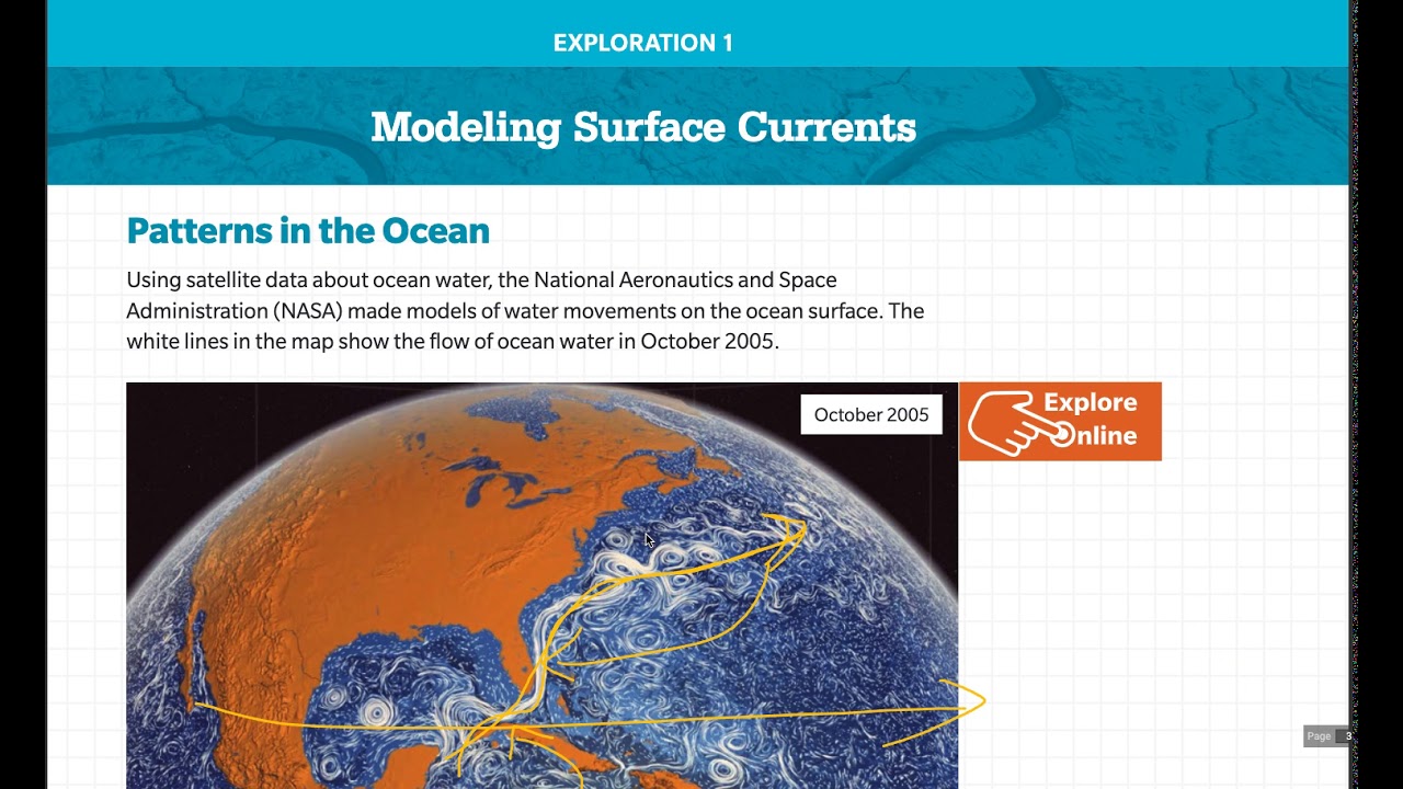
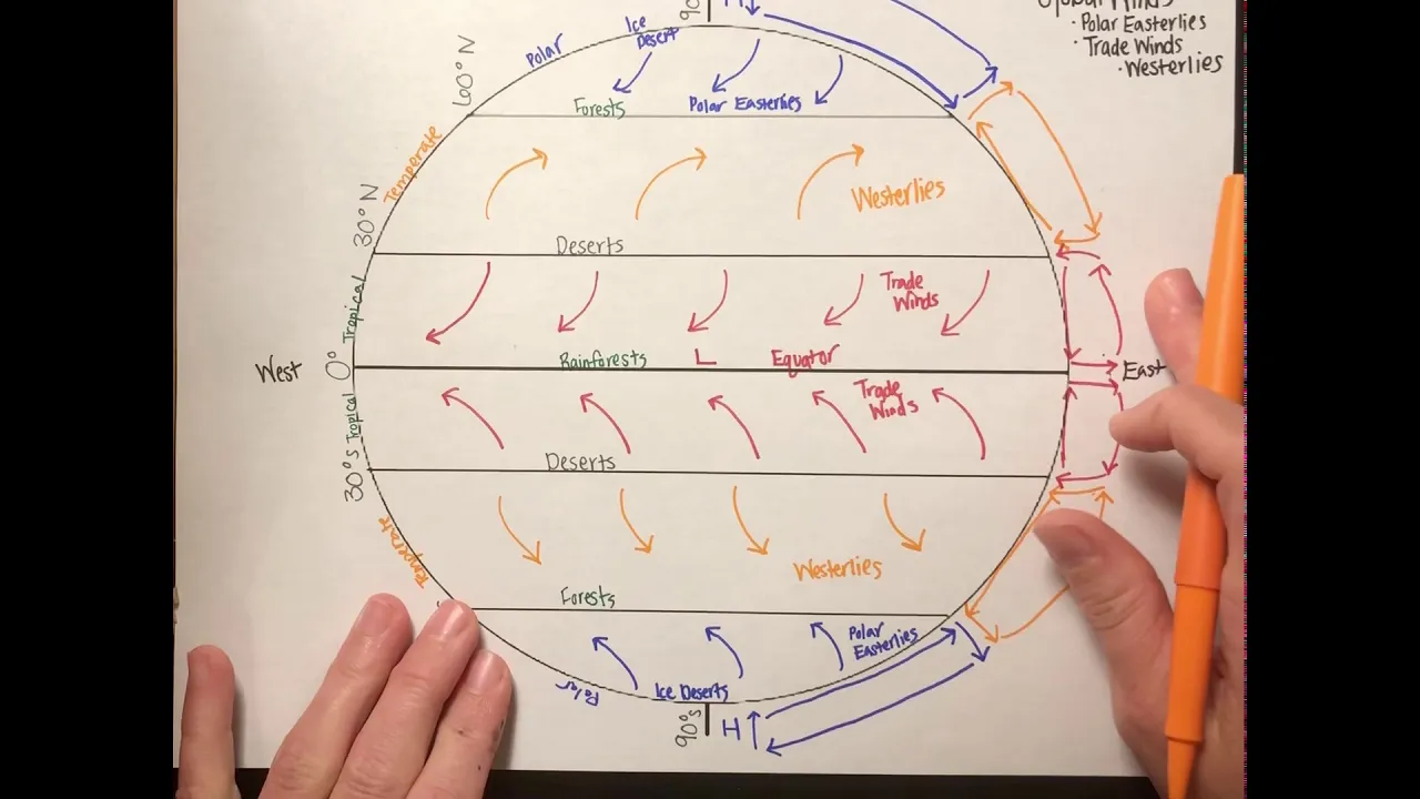
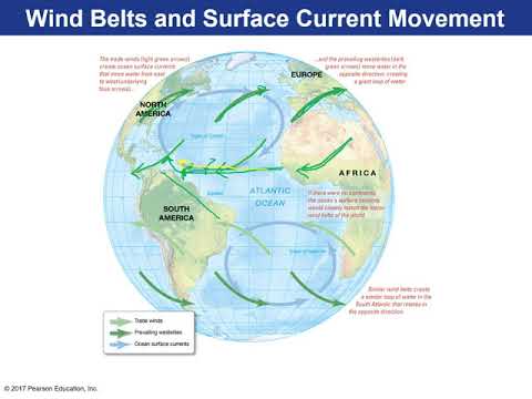
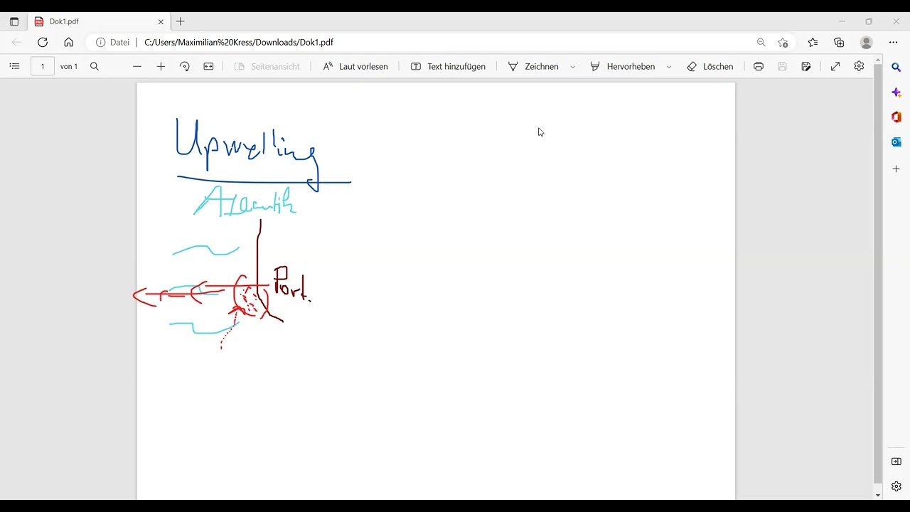
Added:[Music] Hello friends welcome to another video of Zeta axis and today we will discuss the factors causing ocean currents so what is an ocean current an ocean current is defined as a continuous directed movement of sea water which is generated by a number of forces acting upon the Water so in the a large number of forces act on this water which we will see in the later part of this video so because of these different forces acting on the water this water starts to flow and this continuous flow is called an ocean current the first and the most important factor which causes ocean current is wind now we know that in the oceans when the wind flows over the seawat there exists a friction between the wind and the seawat and therefore the water at the surface that is water in the topmost layer of this oen will also start to move but the speed of this topmost layer will be much less compared to the speed of the air now because this topmost layer of water is moving the second layer will will also start to move because there will be a friction between the topmost layer and the second layer but the velocity of the second layer will be much less compared to the velocity of topmost layer similarly the third layer will start to move but with a velocity lesser than the second layer and similarly this effect goes on till the velocity of that layer becomes zero or there is no movement in the subsequent layer here we can see how the velocity of different layer decreases and when the velocity is zero then this the water in this layer will not flow or not move so from here we can see that a wind causes movement in the surface waters the deeper parts of the ocean water are not not affected by this wind and that is why we say that wind causes surface currents and this surface current are responsible for 10% of ocean water so only 10% of the whole ocean water is moved by the surface currents rest 90% of ocean water is moved by deep currents which we will see in this video as well as we will see it in detail in subsequent video of thermo helan circulation and the link for that video will be available in the description now let's see how permanent winds affect the movement of ocean currents here we can see the ocean currents and we can clearly see that in the equatorial region in all these oceans the ocean current is moving from east to west while if we come over here we can clearly see that these currents are moving from west to east in each of these oceans in both Pacific Ocean and Atlantic Ocean here corio current will move from west to east while here the Gulf Stream moves from west to east now if you map the permanent winds we can clearly see that the permanent trade winds in this region they move from east to west and they drag the surface Oceanic water along with them thus causing them to move from east to Western Direction in the higher latitudes we see that the Western Le froze from west to east therefore this Gulf Stream as well as this corio current will move from west to east because this permanent winds they will track the surface water along with them similarly we can see that this Antarctic circumpolar current they also flow because of this Wester leaves here the Wester leaves flow in this direction and therefore this Antarctic C compol current also follows the direction of movement of these vest Lees we can see that almost all the currents they follow the permanent wind direction therefore these winds are the major factor in creating these ocean currents so far we saw how permanent winds affect the movement of ocean currents but here we will see how monsoon winds which is not a permanent wind and its effect on the direction of ocean currents so in the month of summer we see that Southwest monsoon winds flow that is wind will come start from here and will reach our Indian subcontinent in this direction and therefore we see that the Southwest Monsoon current flows and it follows the direction of our Southwest mson however in the winters we have Northeast mson winds which flows like this it starts from the Himalayas and goes in the direction of Indian Ocean because of this Monsoon current we see that the Northeast Monsoon current flows in our Northern India we see now the direction of this ocean current in Northern Indian Ocean has changed now it is Flowing from the Northeast Direction over here so we can see that wind are the major factors which determine the direction of flow of ocean currents now winds also cause another phenomena which is called E transport now we have discussed Amman transport in detail in another video and the link for which is provided in the description this ecan transport is responsible for causing the vertical movement of water so in ecan transport what happens that if a wind is Flowing from this direction then because of the effect of coris force and the force exerted by wind we will see that the topmost layer of water will move in this direction the second layer move will move in this direction the third layer will move in this direction and a ladder is created the net displacement of water occurs in a direction perpendicular from this wind that is away from the wind so here we can see that this wind is flowing in this direction so the net transport of water will occur in this direction now because the water is moving away from the sea so we see that here there is a depletion of water so to fulfill this depletion of water the water from lower layers will rise up and therefore we see that there is a vertical movement of water because of of wind this wind causes the water on the surface to move in this direction a water depletion is created over here therefore the water from lower layer Li Rises up now this effect can be seen only till 100 to 200 M so even this vertical movement does not affect the deeper parts of our oans similarly when the wind is moving in this direction away from the soil the hmin transport will move the water water in this direction now because large amount of water is accumulated over here therefore we see down Welling that is water will start to submerge over here so we can again see that there is a vertical movement of water over here because of this wind and Amman transport again this movement will also affect only in the top 100 to 200 M so the deeper parts of the oans is not Disturbed even by Ean transport now the second factor which causes ocean currents is Earth's rotation and it acts in two ways the first is inertia which causes Western intensification and second is coroli force now let's first try to understand how this inertia causes Western intensification we know that the Earth rotates from west to east and a dragging force is affected on the ocean water but the ocean water is fluid and due to inertia it tries to hold on to its position but because of the dragging force it is carried with the rotation of our Earth but because of inertia which tries to keep it to its location there is a certain lag and therefore we see that water is accumulated on the Eastern margins of continent to understand this let's consider a vessel in which we have water over here now if we drag this vessel in this direction we will see that the water will accumul at in the direction away from the movement because there is inertia in this water and which is trying to keep the water at its location similar thing occurs with our oceans if we see these two as the Continental margins and our Earth is rotating from west to east then a dragging Force occurs but because of inertia the ocean water tries to hold on to its position and therefore we see that there is an accumulation of water on the Eastern margin of continents so here we can see that the wind Force we know that the trade winds also move in this direction that is from east to west as well as because of the rotation of Earth we see that the level of water rises on the Eastern margin of continents while the lever of water is lower on the western margin of continents and this thing is called Western intensification because we see that the amount of water over here is increased that is on the Western margin of oceans we see that the amount of water is increased so remember it is Western margin of the oceans while Eastern margin of the continent on which we see this Western intensification so we can now see that the water is accumulated on the Eastern margin of the continents because of the wind flowing in this region that is a trade winds as well as rotation of the earth so because of inertia the water which was here it was trying to hold on onto its position but the Earth was moving therefore that water got displaced over here so we can see that how this rotation of Earth also creates movement of water we can see that the water is moving in this direction because of the rotation of the earth and the inertia of the water which is trying to hold on to its position now because the level of water is higher over here and lower over here therefore a pressure gradient exists due to the gravity which is trying to push the water from the higher level to the lower level but because of these two forces the combined effect of these two forces overcomes this pressure gradient and therefore we see that water flows from the Eastern side towards the western side causing Western intensification now here is a topographical map of our oceans that is it shows different regions of our oceans with respect respect to its height this is the scale for this we can see that the red color and white color indicate the regions of oans which are higher while the blue color indicates the regions of water which are lower so if we see this we can clearly see that the Western margins sorry the Eastern margin of continents all the Western margin of oceans have higher level of water we can see clearly over here that there is Western intensification on the western margin of these oceans the level of water is higher similar thing is apparent over here where we can see that their water level over here is also higher and similar thing we can see in Atlantic on both the eastern margins of South America and North America the level of water is higher compared to over here now the earth rotation also creates coris force and we already know that coris force is a force which deflects the movement of any fluid if we are moving in the northern hemisphere spere then it will deflect the fluid in the rightward direction you can see that when you are moving from the equator towards the pole it is deflected in this direction while when you are moving from the pole to the equator it will deflect you in the right direction again and similarly in the southern hemisphere the coris force acts in a direction to deflect the fluid in the leftward side so here when we are moving from the equator towards the pole it is deflected in the left hand Direction and similarly when you have moving from Pole to Equator again it is deflected in the left hand side so this Coralis Force plays a major role in changing the direction of these ocean currents here we can see that the coris force is acting in this direction so because of it this ocean current will change its direction similarly here the coris force will act in this direction so its direction changes again here the coris force is acting in this direction so it will change the direction of this current so we can see that this circular MO of ocean currents is because of the coris force so these geysers in each of these oceans are produced because of coris force so coris Force helps in turning or changing the direction of the ocean current but it does not change the velocity of these ocean currents the next factor which causes ocean currents is density which can be changed by changing the temperature or by changing the salinity so any change in one of them will change the density so we will see both of these together so if we see that there is an increase in temperature then it will increase the salinity of the water because of evaporation more evaporation will led to less water but the salt will remain in the water therefore the percentage of of salt in the water increases and therefore sity increases then we see that the density of water decreases because of heating of the water the water expands and therefore the density decreases but as the water expands we will see that the volume of water increases now this expansion of water into the tropical regions it increases the level of water in the tropical regions and therefore we see that there is a gentle slope in the oceanic water from the equatorial region towards the polar region and if we see the salinity then salinity increases it increases the density because density is directly proportional to salinity now because of this increased in density the denser water is heavier and it will sink in the oceans and when this water sinks in the deeper parts of the ocean a depletion is created on the upper layer and to fulfill this depleon water from the subsequent or adjacent regions will flow from that through this region creating a surface ocean current so here as we discussed because of higher heating of water in the equatorial region the level of sea water in the equatorial region is higher while because of cooling in the polar regions the density of water decreases therefore volume of the water decreases and therefore the height of the water in the polar region also decreases therefore a natural gradient exists we see that there is a higher level of water over here and lower level of water the polar region so because of this the gravity will try to pull this water from the higher level towards the lower level however in practice this profile is modified by several other factors acting in the on the ocean water now here we can see the topographic profile of the ocean water that is in which region the water is higher the higher regions are marked by white or red color while in the regions where the water is lower it is marked by by the blue color so we can clearly see that in the equatorial region the water is having a higher level compared to the water in the polar regions so therefore there is a strict gradient we can clearly see that here the water is at a very low level while here the water is at a higher level remember this difference is only in cm it is not like thousands or hundreds of meter difference is created only difference is created in ctim or few meters but this much gradient is sufficient to cause surface ocean currents now we will see the effect of temperature and sity together in the polar regions we know that the temperature is low therefore the density increases because of this density increase the weight of the water is increased similarly in the polar regions what happens that ice is formed now when ice is formed the sea water contains lot of salts so this ice it rejects or throws out the salt by a process called brine rejection now as this ice throws away the salt it increases the salinity in the adjacent water now this water being cool is already dense but with the addition of salinity this density further increases and therefore this water will descend in the lower parts of the uh sea or ocean therefore we see that a vertical ocean current can be seen because of this temperature and salinity effect now in practice we see that this phenomena is mainly observed in three parts of our ocean the first is here on the norian coast then here on the East Greenland Coast as well as in the vle sea of Antarctica so here what happens that water it down down Wells or it goes in the deeper parts of the ocean so at the surface face we see that there is a depletion of water therefore this North Atlantic drift it carries the water from the surrounding region and comes over here to fulfill this depletion similarly the water down Wells over here and to fulfill the depleted water on the surface we see that water is brought from here in fact in vedal SE also we see that there is a local geyser which moves because of this down Welling of water over here so we can see that because of this temperature and sity variation the water in a region will descend in the deeper parts of the ocean on the surface the water will be depleted and to fulfill this depletion water from the adjacent regions will come to this region thus creating surface ocean currents the thermo helan circulation which is a well-known circulation and very important circulation for Distributing heat in our Earth is also Guided by by this thermal and heline parameters we know that thermohaline circulation depends on two things first is temperature difference and second is salinity difference we have a separate video on thermohaline circulation where we will discuss in detail how this Thermo Aline circulation occurs the link should be available in the description now how does gravity causes this ocean currents so we have seen that because of Western intensification the level of water on the Eastern margins of continents or Western margins of ocean is higher in each ocean and therefore there is difference in the level of water the level of water over here is higher while the level of water over here is lower now the gravity tries to pull the water from the higher level to the lower level but we have earlier seen that the trade winds as well as rotation of Earth they counter this pressure but when we go to the do Drums Do drums is the region where there is not much wind the Trade Winds Don't flow at much velocity over there so in the do drums what happens that the pressure gradient because of gravity is higher compared to the force generated by rotation of the earth therefore in the do drums we see counter equatorial current which flows from the higher level of water to the lower level of water so we can see that because of this gravity creates an Ocean's surface current pressure belts also cause ocean currents we know that there are high pressure belts as well as there are low pressure bels now the regions where there are high pressure we see that the sea level will be slightly lower because of the weight or because of this high pressure over here while the regions or the belts where there is low pressure we will see that the level of ocean will be a little higher again this difference is in ctim and not in several hundred M but this slight difference in height is also good enough to cause ocean currents so we have discussed all the major factors which call ocean currents and here is a summary of this I hope you have liked our video so do not forget to subscribe and share it with your friends if you have any doubts you can ask in the comment section and we will try to resolve them if you like our effort then you can contribute to us by using the QR code over here thank you for watching the video
Up Next

Microplastics in Marine Life: Examining the Environmental and Health Impacts
@cgtn
1.4K views•2021-10-22

Life in Biosphere 2: Sustainable Ecosystems & Human Survival
@TED
334.9K views•2009-06-16

Microplastics Everywhere: How Plastic Impacts Our Lives
@TEDx
100.9K views•2018-05-08

Ice Stupa Artificial Glaciers: Solving Ladakh's Water Crisis
@SonamWangchuk66
3.2M views•2015-05-03
Related Study Plans & Knowledge Roadmaps
Structured learning paths in Environmental Science