
















Remote sensing satellites operate in specific orbits (polar, sun-synchronous, geostationary) to observe Earth's surface, with resolution determined by altitude and sensor technology; ISRO has developed launch vehicles (PSLV, GSLV Mark 2/3) capable of placing satellites in these orbits, enabling applications from agriculture monitoring to weather prediction through spectral analysis of reflected and emitted radiation.
Satellite Building Workshop: Remote Sensing & ISRO Launch Vehicles Explained
Added:Basic principles of orbital mechanics, including Kepler's laws of planetary motion and gravitational forces.
Fundamentals of the electromagnetic spectrum and how different wavelengths interact with Earth's atmosphere and surface features.
Elementary concepts of rocket propulsion, Newton's third law of motion, and the concept of escape velocity.
An understanding of basic Earth science, specifically coordinate systems (latitude/longitude) and the layers of Earth's atmosphere.
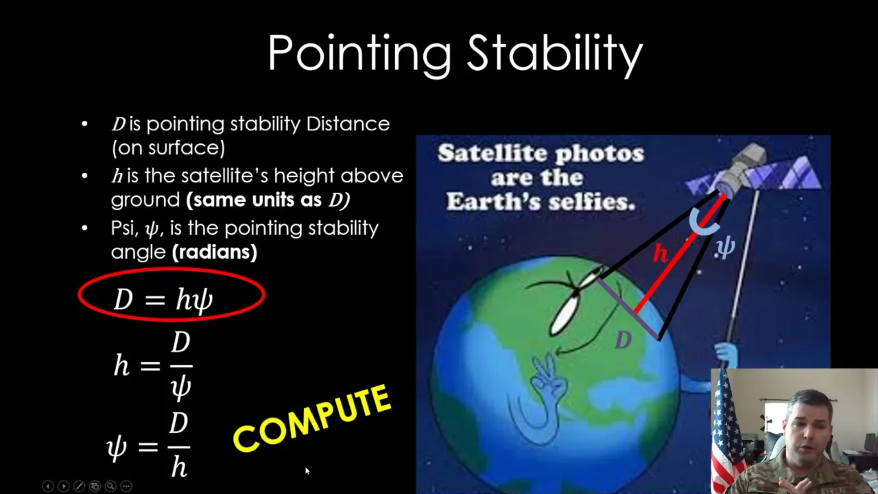
Advanced satellite subsystem engineering, focusing on attitude determination and control systems (ADCS), power systems, and thermal management.
Geospatial data analysis and digital image processing of remote sensing data using GIS software (e.g., QGIS or ArcGIS).
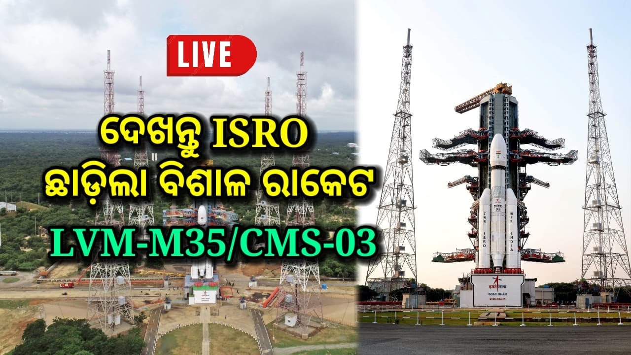
Deep-dive study into cryogenic propulsion technology and the mechanics of heavy-lift launch vehicles like the LVM3.
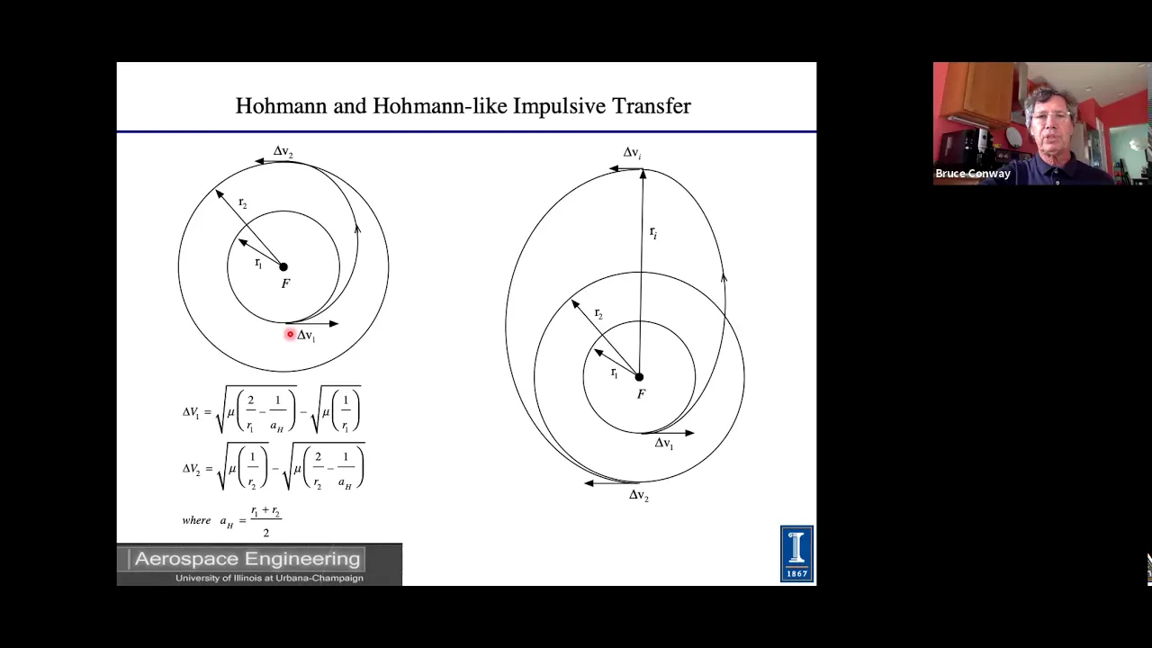
Astrodynamics and interplanetary trajectory design, such as Hohmann transfer orbits used in planetary missions like Chandrayaan and Mangalyaan.
262 views10likes2:17:05Original Release: 2022-02-23
uh you see this is basically an inaugural session of our lecture series uh and today we will be talking about i in the sky and beyond remote sensing of earth and other planets some of you may be a bit surprised i don't know whether you got the input that the first lecture which was supposed to be on launch vehicles that could not happen due to certain unavoidable circumstances and we have to start from remote sensing payloads or remote sensing of the earth and planets the way this lecture was structured was that we will build on the launch vehicles but somehow uh we could not uh pursue with the launch vehicles so i'll give just a brief uh without any uh uh slides probably i'll give you an idea or if you want i can run the slides also as you please you see three four slides it is like that that we we have isro has three operational satellites pslv gslv mark 2 and gslv mark iii all these satellites are as on today launched from satis dhawan space center that is in andhra pradesh and it was up to now it was a nelu district i think now it has changed but okay the location remains same that is only name change so all the satellites are launched and that location was selected in such a way that from this location we can launch satellites which are polar satellites means which go from earth one pole to south pole to north pole and northward to go around earth or revolve around the earth in a polar orbit or we can launch the satellites which are geostationary or geosynchronous whatever you call them which go around the equator or which travel around the equator now the first of our launcher which we used i am talking of operational launches not the experimental launchers say our sounding rockets then slv aslb they were all learning phase but after that learning phase we came to bslv and pslv is basically a four stage rocket which we have been using for a long time and it has a alternate uh liquid and solid first stage is solid secondary is liquid third stage is solid and four stage is liquid and on around the first stage there are four or six or whatever number of depending on what type of capability you want there are boosters four or six boosters so those are again solid boosters now this launch vehicle which has different versions versions come only from basically versions come from the number of the boosters that we attach to the rocket and the size or the size of the propellant loading in the boosters all other four stages which are main rocket they are same you can launch without even boosters but that is how as you go on increasing the number of boosters or their size you are able to launch satellites with a higher and higher mass now one of the version that is pslv xl that can launch about 1700 kg of payload in 600 kilometer polar orbit or sun synchronous polar orbit we will learn what is sun synchronous polar orbit just remember the name that is a orbit that goes around from pole to pole so we can launch 1700 kg from 600 kilo at a distance of 600 kilometer or at an orbit height of 600 kilometer or if we want to launch in see satellites are never launched in geostationary or geosynchronous orbit except for a couple of exceptions otherwise they are always launched in what is called gto or sub gto that means you it is an elliptical orbit with hardest point which is very near to the uh geosynchronous orbit that is about 35 800 kilometer and the nearest point is about 200 250 kilometers that is perigee what we call nearest point we call perigee it is about 200 250 kilometer and the farthest point is uh the apogee what we call and it is at about 36 000 kilometer so that is how we are able to launch that is what the capability of this launcher is there then if we go next then we have uh okay and this i will tell you an interesting up to now we have launched 53 that is why we are calling it our workhorse we have launched 53 pslv different versions out of that there was one failure in the beginning and one more pillar uh in between recently that occurred and uh that is when we were launching our ir nss or navic that some pillar occurred and uh one partial pillar so if you consider everything out of 53 we have two payloads and one partial pillar so it is a excellent record of any launch vehicle operator in the world so that is the thing other thing what we are hour is gslv mark 2 gslv mark 2 uh has had total 14 flights out of that almost i think five or six flights i don't remember the exact number five or six flights have failed or partially failed and remaining flights have been successful this is not a very good success rate but using this gslv mark ii we learned couple of things because you want to why if our pslv was working so well why would we launch why would we have another launcher which is gslv the reason is that the gslv can launch up to a gslv mark ii can launch up to almost 2 2 ton slightly more than 210 in gto so that other fellow our this pslv cannot do so it is 2 ton in gto that is what we were capable of doing and main thing about this launcher is we have our own cryo stage cryo stage cryogenic statement it uses liquids which are cryo cryogenically cold means less than around 150 200 uh 100k somewhere 100 to 150k or even lesser than that so okay they are see you can see liquid oxygen and liquid hydrogen so those are very very cool liquids so we put those liquids and when we put use those liquids they are very energetic liquids so we can get much more thrust per kg of the fuel that we use and if we have to launch satellites to a higher orbit or uh with heavier mass then we have to have cryogenic stage and we developed our 710 cryogenic 17 means that is the thrust that it provides 710 cryogenic stage for gslv and but it is a mixed result but i will tell you another interesting thing that we have jslv mark 3 and gslv mark 3 is capability is 510 in gto that it can put 510 in geosynchronous transfer orbit which i told you that it is an elliptical orbit with perigee at about 250 kilometer 300 kilometer and apogee at 36 000 kilometers it is called geosynchronous transport orbit because that is an orbit which is an elliptical orbit then up are you launch the satellite in that orbit and afterwards using the satellites on engine you can circularize that orbit and convert it into a geosynchronous or geostationary orbit as you call it so that it can launch five ton of course as on today we have had i think four flights today and maximum uh we have launched chandra our chandrayaan to gsat-19 g79 all were launched on gslv mark 3 and initials the first one which we wanted to try out and find out it did not contain the cryo stage but without cryo stage we launched and in that if you remember the what is what care module was there that is crew module and atmospheric re-entry means we we want to send our dragonian so for when we send ghanaian type of satellites or launch launch them then we have to bring our astronauts back and for bringing back you need atmospheric re-entry means it should come and without getting destroyed it is coming at a very fast speed at that point speed without burning down without happening anything it should come down at that speed when it comes down when it starts the speed is about eight kilometer per second you can convert it to meters eight kilometer per second you can convert it to kilometer per hour by multiplying by 3600 so that is the speed but when it lands your speed is very very when it lands it is very one meter per second or 1.5 meter per second so you have to slow down that pass in a short duration and that too without giving larger g forces on the uh astronauts or burning down uh in the because of the friction burning down our module which is coming down so that was also launched by this these are the things and and the last one is that this gslv mark iii has a 2010 cryogenic storage so it is a very powerful stage as on today we have launched up to about four ton in used transfer orbit or chandrayaan type of orbit in low earth orbit and our gaganyan will be launched in gslv mark iii now with this introduction what i want to start is that i want to start our main course because unless you understand this you will not be able to appreciate what we are going to talk now our main talk so it is starting late by another 10-15 minutes initially it was 10 minutes late and i will try to uh are you able to see the screen no sir not yet is it no uh no so not yet to me is is it visible to your kansas here your screen is coming but it is not sharing now present window window or entire screen enter screen sir i did entire screen only but then please click on that screen uh a small window will come where enter screen is present so click on that screen and then share when you will when that box will open no sir click on that screen window and then a blue button will appear as share on bottom did you see that now yes sir it is being presented now okay good yes just click the hide button over there sir uh hide button i don't see hide button there yes not only okay are you able to see yes yes yes so shall i make it full screen yes yes sir and now it is full screen are you able to see the full screen yes sir it is visible now please okay so now we see before we start i would like to mention that our hod shilpa sankar mam is also present over here um hello ma'am okay thank you hello good evening good evening uh good evening sir nice to meet you online yes nice to meet you too online sir and it is a great pleasure that first time uh uh first of its kind we are having such a workshop for our students and it's it's a great pleasure to answer oh so nice of you let us see whether it continues to be pleasure when i end it definitely sir definitely our students are going to have good take away sir yeah yes yes they can keep their questions with them and ask me at the end of the lecture it is little longish but let us see how much patience all of us have and if we lose the patience please raise your hand and we will stop at that location yes see here i am giving a glimpse of what type of remote sensing satellites we have launched where we started and where we are today in remote sensing satellites we have two type of satellites one is our satellites which are there which are we are using for our resources so resources means uh say agriculture water then cartography so those satellites are at about their orbit is about 500 600 kilometer or maybe even 700 kilometer from the surface of the earth it is a circular orbit and it is a polar orbit why polar orbit is there because when you have a polar orbit what happens is the satellite is going from north to south and south to north well below that earth is moving from west to east so all the parts of the earth at some time or other will come under the satellite and you can take a picture so all our remote sensing satellites have our polar satellites we will ascend their sun synchronous that we will see little later as we go so uh except that initially when we started uh our uh uh pascara one bhaskara two they were mostly experimental satellites and those satellites were not uh sun synchronous or they were not polar it was about 50 degree incline to the equatorial plane so now how we that why i gave you the in introduction of the launchers suppose somebody decides that we launch a satellite from a gun here you are seeing a gun which is launching a satellite okay or it is trying to launch a satellite but when we are releasing asset an object from the gun it is not a satellite but it is a project type so we have to understand the difference between satellite and projectile in projectile what you are doing is that most of its velocity or what you call impulse that you are giving in the beginning after that it is a pre-flight under gravity and as long as you are in atmosphere atmosphere drag and gravity but assuming that there is no atmosphere it is only moving under the gravity so depending on at what speed we send it it will be falling very near to the earth or very far from the earth but if you do the calculations of how much force we have to apply and that to go it rounder so that the curvature of the earth is such that when when it's when your vehicle starts curving the earth's curvature and this they coincide they go down equally so then it will become a satellite but for that you will need a very high initial impulse and if you give that type of impulse in the beginning what will happen is that either your satellite will break or you the type of impulse supply which you need will be so large that building them will be unvoiled so you cannot launch as on today it may finally come as on today with available propellants propellants mix fuels and oxidizers available fuels we cannot launch a satellite using a projectile type of motion now here if you see on the left what you are saying is that you see when we are releasing a satellite through our launch vehicle okay launch vehicle is not simply releasing it wherever it is suppose our launch vehicle normally all the satellites are released at the lowest point where the lowest point of their orbit that is called we call it perigee so you release release of perigee whether it is geosynchronous geostationary satellite or whether it is a remote sensing satellite but in for remote sensing satellites our perigee and apogee because it is a circular orbit they are same so you release it at 500 600 kilometer but it is a circular orbit but still it is perishing or it can be sometimes apogee also i will i will why i am telling it perigee is that there is a reason it can be apogee also but the way you are releasing it such a way that if you just release it the satellite will come down it will not remain there the reason is that gravitational force is pulling it down and once the gravitational force is pulling down it cannot remain you can see here on the left side but if you want to put it in an orbit then you have to give a horizontal velocity also or tangential velocity as they call it correctly so you have sufficient tangential velocity now i will talk in engineering terms rather than physics term so tangential velocity when a vehicle is moving with some tangential velocity it is experiencing some centrifugal force the force which is trying to throw it away from the center of the earth and that is m v square by r correct that is that is the centrifugal force and the earth is pulling it down with because of gravitation and that force is m mass of earth multiplied by g that is gravitational universal gravitational constant multiplied by the mass of the satellite and then divided by r square so where the satellite will go you balance these two forces centrifugal force so you will get a value of r so depending on what velocity you have given it will go in that orbit r because r and v will be fixed automatically r once r and v are fixed means period is fixed height is fixed r is height so period and uh r will be fixed so if i want to launch in a particular orbit i have to give a given velocity by our launch vehicle and that is why because we have different type of launchers they have to give we have a given payload and to that or given satellite which is a particular mass now i have to give that much velocity tangential velocity first i have to take it there up to a height where i want to release the satellite and then give a tangential of course both of these things are happening simultaneously but let us for understanding purpose let us say that when once we are going up up to say 500 kilometer or 250 kilometer and then you are giving a tangential velocity so that it is it will go around the earth so our launcher should be capable of giving that much tangential velocity to the satellite which has a particular mass and that is why because it doesn't have that capacity it will not be able to launch and the satellite will come down now here you can see now how how how satellite does it see satellite what type of velocity it has to give how do you determine in which orbit satellite suppose i have given some velocity then it may go to any orbit so that is not so arbitrary here you can see on the bottom there is an equation which says that now for a given orbit is eccentricity of the orbit it is an ellipse let us assume so if that ellipse let us say assume first that ellipse eccentricity is 0 i want only circular orbit circular orbit means this 1 plus e term in the bracket will vanish so for a circular orbit i will give a velocity v which is equal to gravitational constant into mass of the earth divided by the uh perigee radius that i have to do if i give that much velocity then it will be in a circular orbit for a given perigee radius but if i want some eccentricity for i put that accent eccentricity how do i determine it is very simple say you say your ellipse all of you know how to find eccentricity so from that you find the eccentricity put that extra entry means how how far you want your apogee how far you want our perigee so apogee minus papaji means you have to consider from the center of the earth apogee minus perigee plus apogee plus very and this you are considering from the center of the earth not from the surface of the earth so from that i determine what is the eccentricity i need for a given type of orbit and then i give the calculate the velocity and by releasing the satellite out i give that much weight so if i give suppose a velocity which is e is zero then i will go in the circle like this i give higher velocity then it will be an ellipse i give much higher velocity then it may be an escape velocity i can make it parabola or hyperbola means it will never return to earth so that type of thing you can do by simply by deciding the height at which you are releasing and at that height what type of velocity you are giving now you can have here you can see different type of orbit this is a very elongated orbit okay and this is called highly elliptical orbit then you have slightly lower elliptical orbit but this this is almost a polar orbit type of thing and this is our geostationary orbit see these are the diverse orbits and i have not drawn here all the orbits but we will go through those things little bit little by little now how do you determine or how orbit is defined that we have to understand see orbit is defined let us say that i want to define an ellipse what parameters i need of ellipse i need eccentricity and semi-major axis so if do two parameters are there i can define an ellipse so i have defined the satellites orbit now i want to put that orbit in a plane around the earth how do i do that i again need two parameters that plan here you can see yellow plane is inclined at an inclination of i okay and that inclination is with respect to the equatorial plan so i need i and i need where it will intersect where it will intersect these two planes where they will enter of course they intersect in a line but if you see the exact orbit because it is not a plane actually it is an orbit it will be two points one one point is where the satellite is going from below the equatorial plant to above the equatorial element means from south to north and that is called ascending node and other point is from north to south it is going and that is called descending now so if i say i define a an inertial direction in space and tell that my point of intersection is so many degrees from that inertial reference which i have given i will not go into how it is very simple to define an initial reference frame so then i need two parameters that is ascending node and the inclination so now i have defined a plane so i can now put my orbit in that plane once i put my orbit in that plane okay now i want another thing to know and that is how to see i can rotate in the in i can rotate my orbital plane anyway in this uh plane the plane which i have defined i can rotate anyway so where it will be rotated what will be the so then i have defined argument of perigee that means where the perigee will be there with respect to the line which is joining ascending knot and descending node and that angle you are measuring in the orbital plane so that is my argument of perishing so now i have fixed the ellipse so i have defined ellipse i have defined the plane in which i am keeping the ellipse and i have fixed the ellip in the plane so these three things have happened now to know the position of the satellite i know true anomaly which indicates the position of the satellite so these are called orbital element or keplerian element which more many of you would have learned but i thought that we should understand the significance of six parameters then we don't have to remember those parameters you will automatically know that you need two parameters for defining ellipse two parameters for putting a plane with respect to our equatorial plan one parameter to fix the location of the ellipse in the plane and one parameter to find the put define the location of satellite in the orbital plane that is how we define keplerian elements now here i am telling what type of orbits the satellites are normally put leo that is low earth orbit low earth orbit what you are doing is that it lowers orbit can be you see we have we are telling low earth orbit so it is less than thousand kilometer orbit around that that is from the surface of the earth now it may make any as long as i am not giving any condition on the orbit it can be in any plane so it can make any inclination with respect it can be even zero inclination or it can be 90 degree 97 degree other way around you go all the way it can be any inclination and that is called low earth orbit and then you define what is inclination what is orbit height or what is the height of suppose if it is a an ellipse elliptical orbit then you have to define both apogee and perigee if it is a circular orbit you define only the radius but then we have sso now what is sso that is sun synchronous orbit now why do you need these type of orbits most of the remote sensing satellites need this type of orbit the reason is that when on whichever location you are taking picture a satellite is supposed exactly overhead over ah or for that matter puna or bangalore that always see it will come at any location two times any given location two times a day not every day but whenever it comes it will come two times so whenever it comes on a given latitude the time will be same so we define the latitude time of equator so equator crossing time so equator crossing time will always be same throughout the year it will always cross equator from south to north that is ascending north or north to south descending node whichever you have defined it will always go now for doing that what you need what you need is that the plane of orbital plane actually rotates orbital plane itself rotates around the say almost around because it is a polar orbit it will rotate around the axis of the earth more or less episode of course it's one axis but its own axis is right now very similar to north south uh our pole to poll axis it rotates now you control the rotation here you see delta and how the rotation is defined ascending node you see ascending node we have defined if you remember that is omega so omega is where orbital plane is this uh intersecting the equatorial plane that location goes on changing now if you change that location what happens is that time changes but what i am doing is that now every day earth goes around the sun by about 1 degree that exactly we are not talking but about 1 degree 360 degrees and 365 days so about 1 degree so you make this plane also rotate 1 degree per day now here the rotation of the plane is given so how it will rotate so there is a given inclination all other parameters suppose they are picks if other parameters are fixed that is because you you know you want to launch in a particular orbit you have a particular say even its momentum is given so all those things other things let us say they are fixed now only parameter with two parameters which are under your control are inclination and uh orbit height r e uh no not rep p square p square and r cos i and p square these are the two parameters so means i want to put at what orbit height and what inclination so there are pairs this pairs if you launch a satellite with that pair of inclination and the orbit height then it will become sun synchronous so that you will take pictures under the same illumination condition of course over the years sun goes from north to south that you are not correcting but that is a very slow motion so from day to day you can compare your picture without much of a problem illumination conditions will remain same that is why we use sso then the middle earth orbits you know all of us you know that a gps all gps satellites are in middle earth orbit and they are at about 20 000 kilometer from the surface of the earth that is because number of they and they are in different place and they have put it in such a way that at any given location you will be seeing minimum of four satellite in good configuration good continuation means what they are not one either they are not together all four of them or one is at horizon and other at middle and so otherwise it will be difficult so in good configuration what they call a dop so they put in a different or with different plants about six plants are there in each plant some six or seven satellites are there and those satellites are such that with having a poor satellite receiving data from four satellites together using that data your receiver can calculate its position remember gps never knows the position of your location only the receiver knows because the position is calculated by the receiver not otherwise it will be chaotic they are sending the data now because see if i want to know my position i need three parameters i what what are the pyramids latitude longitude and altitude so i need only three satellites because three unknown three equation but fourth is that because there is some time error also because time on the ground which is of course you continuously you are synchronizing your receiver but receiver is not fully synchronized all satellites are also not so there will be a delta time so fourth is delta time so this four parameter you generate four equation solve those four equations you know the satellite from the satellite data which is sending you know the range of the satellite knowing the range of the satellite that is r square r square is you assume the parameters of your location and then x 1 minus x 2 whole square plus x f y 1 minus y 2 whole square and that 1 minus z 2 whole square solve that equation and you will get your location that is of course it is slightly complex i am simplifying it so these are these satellites are in mio satellite that is middle earth orbit that is the way they are done is that number of satellites and the power they want to transmit you have to do a trade-off and doing that trade-off they found that this is the best way of doing particularly when you want to cover the whole world then there is another orbit which is called molniya orbit but before i go to malney orbit i made a mistake i should have gone to geo orbit here geo orbit is which because what is happening all our communication satellites are in geosynchronous earth orbit that is means they are at 36 000 kilometer or whatever number you see is 35786 i call it 36 000 for it doesn't matter for our discussion and they are it is an equatorial orbit means it goes around the equator at 35 000 now as i told you that at a given radius of the orbit the satellite has a particular velocity angular velocity or uh tangential or linear velocity whichever because r omega is a tangential velocity and omega is angular now you place as you go on changing the orbit your tangential velocity changes so at 35 000 kilometer 36 000 kilometer your angular velocity is same as that of the earth's angular velocity that is one degree per whatever that between 24 hour 360 degrees so it it also goes around earth in 360 360 degree it covers in 24 hour so from any location that satellite will appear stationary to you now advantage of this communicate this type of communication you don't want to cover all earth here see because from any given location you will be able to see about one third of the earth only thing is that if because this is on equator if you draw a tangent to the uh pole it will not go up to the pole it's it it will just it will be go going up to 80 81 degree if you do it and it will be seeing and both north so beyond 81 degree both on north pole and south pole you will not be able to do the communication very well using this type of geostationary satellite because you don't want to move your antenna so you all communications sub let us assume that tata sky or airtel or whatever they are suppose when they distribute your every time you have to move your antenna it will be chaotic and because they cannot keep beam very large they keep narrow beam because if beam large means your power goes down your power goes down means you need larger antenna so beam is very narrow so all the energy is concentrated in a smaller beam because it is a smaller beam slight many of you must have seen if my settler my ah that dish at my terrace most little bit it signal will be lost so and you don't want to go on moving that so to do that it has to be in geostationary orbit now as i told you geostationary orbit has one limitation it is a very strange orbit when you go as you go away from the equator so lot of loss is there loss is almost proportional if i remember a right proportional to the r square the distance that is range square so as you go away from equator range becomes larger and larger and lot of hand signal becomes poorer but russia the problem with russia is that its entire path enter russian region is very much on the north and up to the north pole arctic now they cannot use these satellites very effectively so they found out an other method that is use this orbit which is called malnia orbit that is why i thought ah a gto's geo should have been passed so money orbit it is an orbit which is inclined at 63.4 degree with respect to equator it is a 12 hour orbit and that orbit is such that farthest point is about 40 000 kilometers so satellite dwells at that location very long time because it is a 12 hour orbit and because it is almost on the equator on the call north pole now so two conditions are there that this this plane should not i told you that plane goes on rotating you omega so you don't want it to rotate i if i don't want to rotate if you i have given the equation you solve that equation for zero rotation say omega omega dot omega dot zero means i will need uh say say 3 uh 60 degrees just one minute just a minute so i will need 63.4 if i put at 63 point my orbit will not rotate in the same plant so north side of the farther side apogee will always remain on russia and other thing is that i make it a 12 hour orbit so it will go and come back at the same location after so if two satellites i put then it will be good enough my i will have to move my antenna very little because as per kepler's law remember equal area in equal time so because now whatever for equal area here my arm length is very large so movement of the satellite is almost zero there is little bit of movement but almost zero so you can keep your antenna they keep slightly they can afford to keep wider beam because what happens is that you are only covering this much area you don't want to cover other things with this so they use many of them use this type of orbits now we have seen types of orbit which are used now in our remote sensing satellite we use both sun synchronous orbit and geostationary oil you will think that why we use two types of orbit see sun synchronous orbits have some advantages you see what is the see orbit determines what part of the globe you are being doing so if i have sun synchronous orbit as we discussed i can view any part of the earth because i am going from north to south earth is moving from west to south west to east so every part of the earth will come under the satellite at some time or other so a sun synchronous will allow that then if i put at a very large distance that means i put r very large then what will happen is that the i will be able to see a very small area at any given time not only that for my angular for a given angular resolution means what angle my sensor sees on the ground that will become large so i will not be able to see the details so so i i cannot see the detail but on the contrary if i am at 500 kilometer 600 kilometer my for a given angular result i will show you what happens is afterwards so for same same apovi if i were very far further that is angular rapid i was very far then i will be able to see only sketchy details on the ground but i am at 500 600 kilometer you will think why not 100 kilometer then you never ask that because you remember today what happened how many of you remember of ellen musk's uh starling satellites see elon musk uh 40 satellites uh were burnt today more or less they were burned all of them have not come down but they have become defunct what happened is that there was a magnetic storm that magnetic storm what it did it heated up the atmosphere those satellites were there 49 satellites that they had launched on third of february those satellites were only at about 200 kilometer orbit our atmosphere because of this geomagnetic storm from the sun or coronal mass ejection because of that what happened is that our atmosphere got heated up and it went up when you heat up your atmosphere expand so it went up to 200 kilometer they tried to stop it but they could not do it they tried to go to uh safe mode they and 40 of their 49 satellites were lost so you cannot put very low otherwise this is what will happen so you have to put satellite even our say international space station it is at about 400 kilometer even without or with geomagnetic storm it comes down about every 15 days it comes down about 20 25 30 kilometer so they have to lift up continuously but because the people are visiting there you can effort to do that you can go on filling the petrol like what we are doing in our car but if it is a satellite which doesn't have people on that and it is you are not accessing it any other time you cannot afford so you have to put at a slightly higher so 500 to 700 kilometer less than thousand kilometer orbit is ideal for remote sensing satellite but the coverage that is suppose i have gone to one i told you that i told you that this any part of the satellite given part of the satellite will come and part of the earth will come under the satellite sometime or other now that some time or other it is not always i am not seeing that part i have to that is called revisit i have seen this part today after how many days i will see the same part again that is revisit so revisit is not very good here it can be 5 days 10 days 15 days but sometimes you can if i don't want to see other areas i can tilt my satellite and see within one or two days but still at a cost that is because i am not seeing some other areas which may be important but you have to live with it because it is a trade-off and then what happens is that the satellite remains continuously one side is continuously illuminated other side is night sight so you can do calibration of the satellite and it goes around earth in about 100 minutes so it's very fast after 100 minutes almost for 50 minutes are available to you for taking pictures this source this is a a polar satellite you can see earth is moving going from west to east and uh here it is slightly tilted wrong way around but west to east it should go and what happens is that nearly constant illumination is occurring because of the polars and synchronous orbit better special resolution you are getting as i told you global coverage is possible because and this but what happens is that because it is still near with 7000 to 700 2000 kilometer so what happens is that its life is not very much life is mostly determined by the fuel that you can load in the satellite so anyhow you have to do some correction and in the correction you lose lot many fluids and when you lose the fluids or propellants will be what we call or fuel what we call and then it doesn't now that is okay but suppose for weather i am not for weather i am not interested in very small details what i am interested in is that details may not be as good but i want to cover a larger area and i want to see that area repeatedly all our weather satellites you must have heard the name of kalpana weather satellite inside 3d or every day you must be seeing pictures by imd or when the tornado or what we call hurricane is there how it is moving where it will go all those details are obtained from our inset 3d and 3dr satellite of course now earlier it was kalpana but kalpana lived for a very long time now it has been put to rest so now what happens is those satellites they can take a picture of the given portion of one third you have put it over india is india center so one side of the globe of course not covering uh pulley or north pole and south pole 80 degree 81 degrees or south pole to 18 uh one degree north pole that much area and in this also 81 to 81 degree east west also so that much about it will become about one third of the area of the earth you can continuously see and you can take picture with our inside series of satellites every half an hour resolution is not good but it is continuously available not only that i can change the scanning inside 3d mirror such that a given area suppose i am concentrating on a hurricane then i can uh if that hurricane or whatever name you are giving that if i want to see only a small area i can reduce my skin and every five minute i can can that area of say 200 kilo 400 kilometer by 400 kilometer or 200 every four or five minutes i can see and i can track it how it is moving so that is the advantage of geostationary orbit particularly for weather not only that i can get from from the inset 3d series of satellite i can get the wind velocity i can get the cloud motion i can see even humidity i can see measure the ozone so continuously i can make those measurements using my and those are very frequent measurement every two hour three hour i can get full measurement those are useful for weather prediction so for weather whatever weather predictions you are seeing those are happening not only from the satellite but lot of data from the satellite goes into the weather prediction model so we are using that now we will try to understand how the remote sensing satellite works finally remote sensing satellites when you are tired please tell me atharva and uh santoshi we can stop for some time and we can start again okay sir whatever you feel comfortable sir right now it is okay i will tell you yes so see finally what we are measuring is radiation now as you all know by planck's law the radiation at the peak of the radiation as the temperature of a body increases the peak of the radiation shifts towards the lower wavelength or higher frequency so see and you can find out see my let us see the bulb i apply very little voltage to the bulb bulb will appear red then i go on applying higher more and more voltage it becomes white that means it is spectrum or spectrum means the content frequency content or wavelength content or color content changes so here we can see now for our eye total if you see electromagnetic spectrum that is the electromagnetic waves it goes from all the way from cosmic rays which are very low uh wavelength that is you can see here x-rays let us everybody knows x-ray it is about one to four angstrom now one angstrom is one raised to one into ten raised to minus ten meter that is one tenth of a nanometer so about three four nanometer four nanometer i mean four point four nanometer x-ray is called soft xa well one nanometer one angstrom x-ray is called hard x-ray so all our medical mostly they use one angstrom type of x-rays so starting from x-rays to 100 meter that radio wave you have this full spectrum out of that full spectrum only from 0.4 micron that is 400 nanometer 2.7 micron that is 700 nanometer our eye can see but we can put sensors which can see our entire this wavelength that is the capability of the sensors not only that we are making all the measurement now on the ground i will not go into this slide because it it again repeats where micro what is the frequency of microwave what is the wavelength of micro what is the wavelength of infrared what is the wavelength of visible ultraviolet ultraviolet of course as you know is from almost 100 nanometer to 400 nanometer just less than our blue light so sorry uh this uh i will not repeat now i will tell you an intro now when i am making measurement say from a satellite off the ground i have two things one is that i have the solar reflected radius that is how radiance means it i am calling it a spectral radius spectral radiance means what i am telling is that it is with respect to wavelength or with respect to color so this is what i see reflected radiance from the ground that is sun is illuminating the ground it passes through the atmosphere of course i am not uh here uh included atmospheric effects but suppose on the top of atmosphere this will be the radiance that i'll be able to measure at each wavelength which is total about 1300 watt per meter square type of thing and then earth is at about 23 degree centigrade 25 degree centigrade so it is also radiating so it is emitting so that is the emitted radiation of the earth now if you see clearly it about at about 4.5 micrometer wavelength the emitted radiance of the earth increases much more or is much more than the solar radiance so i can suppose i am i want to see anything what is reflected radiance i can see about 1.52 micron 2.5 micron beyond that the radiance which is coming from the earth will mix up with it and i will not know whether it is sun's reflected energy or earth's emitted energy and both will have a different characteristic suppose there is one target target is radiating also and it is uh reflecting also so in this radian in this region there will be a confusion so to avoid that confusion what you do is that when i am making a measurement in this radiance in this measurement say from three micron to six seven micron because if i want to measure the earth radiance i will make those measurement at night because there is no sun and if i want to make the measurement on the sun only reflected it is very difficult to branch so i don't do i normally make emitted radiance about say three micron to five six micron i will be making those measurements at night of course finally at night if i i'm making measurement at 10 micron 12 micron that is you are measuring infrared radiation or heat you are measuring so that i can do either day time or night night so many our instruments are some of them are operating in this region many of them are operating in visible region and some of them are operating depending on what you want to measure your measurement wavelength will change or what i want to what is my target what i want to understand what parameter i want to divide depending on that i'll decide where i'll make the measurement in which color i will make the measurement or at what wavelength i will make the measurement now when i make the measurement as i told you that in the previous slide i told you that sun's reflected energy and earth's emitted energy but that is above the atmosphere but atmosphere you can see here there are so many wavelengths which are absorbed by atmosphere so if i am making a measurement from the space there are the blue here in the what you are saying are called atmospheric window so you can make measurement only in the atmospheric window because once even if the earth is radiating or sun energy is coming it may some of energy may reach but atmosphere will attenuate while sun rays come through the atmosphere on the ground and wind reflect so most of the energy will be absorbed so you have to make measurement you have to remember only in atmospheric windows that is why you will see only our all instruments take care of this and they make measurement at particular wavelengths only except that sometimes i want to make a measurement of a say water vapor here you can see water vapor somewhere around 5 micron water vapor here water vapor is absorbing a lot here 5 6 micron what i can do is that i want to find out the content how much water vapor is there so i know how much elimination from the sun is coming and finally when i get back atmosphere or 300 km because earth is at 300 kelvin i i i know uh what is the radiance i should get and how much i am getting because in that wavelength that will tell me how much it is absorbed in the atmosphere and from that absorption i can find out how much water vapor is there in that column through which the radiance is coming so sometimes you can even use that information sometimes you use that information in a different way in the sense that i am making measurement where which are windows but still to some extent water vapor is affecting so i will make one measurement of the water vapor in water vapor band then i will find out how much attenuation and i will add that attenuation to that my measurement so that i know that this is what i should be getting in the absence of water vapor so this type of measurement this is what we call remote sensing now the first question is how do i differentiate whether it is say wet soil whether it is dry soil where it is vegetation so every if i draw wavelength or color versus the reflectance every target on the earth will have a certain signature this is called signature how it will vary with how its reflectance varies with wavelength that is called spectral signature of that particular uh target now what i'm measuring is radiance but i can find out reflectance because i know how much sun is illuminating it and how much atmospheric abs absorbs that so i can suppose i am seeing in the window there is no atmospheric absorption and sunset temperature we know at 57 kilo 5700 kelvin or 58 so i know how much illumination was there at that wavelength from blackbody radiation planck's curve and how much i am getting so i can find out what is the reflectance now at suppose at this so my reflectance i suppose i have again three equation and three unknown suppose only suppose three unknown again i can solve the equation and find out how much is dry soil there whether the soil is dry soil there whether it is a wet soil or whether it is a vegetation so it is only from spectral signatures that you can find out the characteristics of the targets that are there on the earth you are measuring only radiation and from the radiation measurement you are deriving various parameters of the targets now we have two type of remote sensing sensors one are passive sensors passive sensors means what either camera radiometer human eye means somebody else is eliminating that target in case of say sun or say earth is radiated so the source is not with you source is somewhere else and you are that source whatever illumination it is doing reflected or emitted energy you are seeing so those are called passive senses well active sensors what you do is that you don't depend on external source you carry the source on the satellites like radar sonar lesser so you illuminate with lesser you eliminate with radar radio radio frequency or you in in our measurement sonar many times you illuminate with sound waves and those sound waves are reflected in you measure the scattering or reflectance so those are called active sensors so say simple thing is that whether we take a camera with place or without place when it is with no place then it is a passive sensor camera when you are using a place it is an active sensor now this i will not go into the details because i have told you all the things now now in what way we do imaging we can do imaging in basically three ways one is called frame area i put a camera like what we have we use our cameras in our mobiles or earlier we used to use have our digital camera you take a snapshot and that snapshot is taken simultaneously of the entire square or rectangle whatever you want to design that is called field of view so pascara tv was like that where we were taking snapshots of 300 kilometer by 300 km you take one snapshot let the satellite move before it moves 300 km take another quickly because you don't want to take have a longer exposure otherwise satellite is moving so there will be a smear so you take very fast those things and then wait till you reach the net you know when it will reach how much it has moved because the satellite motions linear velocity is fixed at a particular height so you take snapshots so that is called frame cameras or area steering you are doing steering other thing is what at any given time you are seeing one or couple of pixels only picture elements and then you are scanning and when satellite moves in other direction it is moved take another strip so strip by strip actually one pixel before satellite moves total one pixel you cover one strip go to the next strip again next strip you cover so this is what we are doing these are called optomechanical scanner in our vhr or insert series whatever i told you that we have very high results in radiometer which takes the picture of the earth every half an hour so it is this type of sensor but there satellite is not moving so we have to move mirror in two direction take one picture in this direction say east west direction move the mirror a little north south and slightly in the north or south depending on how you are taking a picture take another strip just so pixel by pixel and strip by strip you cover but you are doing very fast one strip of about eight kilometer or nine kilometer you are covering all one one end of the earth to another end of the earth you are covering and that two at equator you are covering in about one second so you can take those pictures very fast and then you can generate take this data send this data and generate now there are reasons why you do that other is that what what we call is that line scale camera so you have large number of sensors not and they are all all our remote sensing satellites are of this type this is our weather satellite this is our remote sensing satellite we have a linear array so in one direction across the motion of the satellite that suppose satellite is as we as i told you that all our remote sensing satellites are going either north to south or south to north means they are going both way but we can take picture in one direction other is night so of course if we have ir we can take those pictures but if we have only visible sensor we can take picture only one type so suppose i am going from daytime is from south to north so i take strip by strip image one strip let the and then send that data when satellite moves by one strip then i take another strip and go on sending that data so i have large number of detector in the crosstrack direction or what we call swath that is across the motion of the satellite 90 degree to the motion of the satellite so you cover those strip by strip and that's those strips because your large number of satellite you get advantage of signal to noise ratio so most all of most of our most all of our satellites which are their remote sensing satellite we are using this because then our efficiency is good coverage efficiency is good we get signal to noise ratio but here because you do not have that time constraint you see here you do not a time constant is in your hand here time constraint for low earth orbit satellite is moving well in geostationary orbit satellite is fixed so you can decide when your mirror mirror only penalty which you will get is that to cover the entire earth you will take longer so you can afford to do that and you have to calibrate fewer number of sensors your life becomes easier particularly for infrared wavelength here in irs so far we have not uh or insert this low earth orbit series in indian remote sensing satellite we have not used ir sensors and we have not used ir sensor so we can effort but now even ir sensors in strip mode have become started become available and probably we may use these sensors but here because that constraint is not there that you have to cover this area this much fast otherwise you have to scan very fast because the satellite will move away and you can't afford to do that of course landsat was doing that but then there are other limitations your signal to nitrous you have to increase by some other means because your integration time for the signal is very low some of you would have heard the name of laura that is long range oblique photography suppose i am at the border i am flying along the border and i want to see the area beyond border then i don't look straight down here but i am looking sideways i am looking beyond my border and that type of thing i am doing that is long range oblique photography i am looking oblique so some of the sensors which are there on aircraft mounted and when i want to do re-kanesha i do use this type of sensor of course our uh radar set which is radar set 1a which will be learned tomorrow it also looks oblique but it doesn't look oblique that much but it also for proper operation it has to it is not looking oblique for this reason which i am telling that you can't go into somebody's border and take their pictures we have to take within we have to remain within our border and take the pictures uh for reconnection purpose from somewhere so that we are doing from aircraft i have so nearly we don't use that isro doesn't use that but if they are being used that is called laura but our radar set which is to be launched by tomorrow morning i think less than 12 hours by now unless they have changed the schedule i have not read recently so it will be launched and that also looks slightly island but that isn't looking is for some other purpose because it is a radar satellite or it is what they call you will look into it with the time permits we look into that but this is what we are doing now what are the types of resolution so we suppose i want to look fine detail then i will call it a special suppose i want to look at say half a meter 0.25 meter 1 meter 10 meter 10 meter 12 meter or angular resolution mean it will be for sensor it will be better to say say 1 micro radiant 0.5 micro area 10 microarray and 50 microargument 100 micro radians so if i look at finer retain that micro radian also i have to be smaller and on the ground strip because that ground strip will be nothing but micro radial multiplied by the arm length that is height of the satellite or radius of the satellite or from say uh satellite height to the surface of the earth where it is looking range so range multiply by uh your angular resolution will give you ground resolution so that will call it spatial resolution spectral result how many colors i am looking very narrow color i am looking or white colors white color bands are okay for me so that is called spectral resolution then radiometric how small change means because if i i want to see a very small my red signal may be say one volt but i want to see one millivolt or one micro volt joint change on that one volt signal do you think i can see or not that will depend on the noise of the signal how much noise it is there so that is called radiometric resolution so my radiometric resolution and last one is temporal resolution means how frequently i'll be able to come through so these are the resolution which you define for remote sensing satellites now i was telling you that our vhr or our insert 3d sensor it's a 3d sensor say a visible sensor has a resolution of one kilometer but still we are calling it a high resolution imager and for our remote sensing satellites say cartosat-2 also is more or less one of course its resolution is better it is its resolution is better than one meter but angular resolution difference you see it is only 50 times of thing say not at 50 125 right say my angular resolution of inset 3d visible is about 25 micro radian while my angular resolution of cartosat 2 is about one microarray so angular resolution is only twenty five times but you see now what happens when i am looking on the ground okay one is at thirty six thousand kilometer other is at uh five hundred kilometer or six hundred kilometer so one uh at 500 kilometer one micron will give 0.5 uh meter resolution but when i take it to 30 000 my my resolution for 25 micron i will have a resolution of one kilometer so when i go up more up here it shows for the same micro radian resolution on the ground when i am seeing i am further away from the ground my resolution deteriorates very fast so that we should understand that even if we are calling it very high resolution radiometer vhr its resolution angular resolution is higher not the resolution on the ground say for in say our it is one meter slightly less than one meter if your car was at three it is 0.25 meter but they are all at lower of course their angular resolution may be 20 25 times better but the data which i am getting from uh instead 3d imager or earlier kalpana vhr very high resolution radiometer they were earlier were two kilometer in kalpana and one kilometer resolution invisible from only thing is that because you are very power you want to see our larger area very fast because for atmosphere say you don't want to for atmospheric study i don't think you need one meter or point five meter resolution particularly the type of atmosphere which we are want we want to understand the atmospheric and put it in atmospheric motor so these are good enough that is what we were told by imd and that is what we are using now you can see special resolution as the special resolution how you see the same ground suppose you are seeing at 0.5 meter wi-fi the details that you can see and 20 say 10 meter by 10 meter or five minutes you are not able to see those details so special resolution tells you what details you will see here you can see 30 meter resolution and the same area if you see here this red area here you can see how clearly and this area at 30 meter you cannot see similarly radiometric resolution as i told you is sensitivity now sensitivity means finally what i will do is that i if i do not have a good signal to noise ratio i will not have a large number of bits i'll send the data in 2-bit or 3-bit or 4-bit so if i send the data in 2-bit you can see how it will look and send a sender data in 8-bit so radiometric result you can see the difference the details that i can see similarly temporal resolution so this are the various resolutions which we talk we talk in general the basics of remote sensing now we will go to imaging missions of india but we will take some break small because one and a half hour less than one we started about 6 15 i have talked for an hour we can have a break for 5 10 minutes hello hello somebody there yes sir yes can we have five minutes break yes sure shall i stop staring yes sir that can work out uh sir you have to go to the google meet window and there you should you can click okay so students we are having a five minutes break over here so as the question answer question answer poll has been opened so please ask you can ask for questions here what i thought was that basics i will cover a little more detail because as i understand all students are from college and they have science background so if we understand the basics of remote sensing other is what type of satellites or what type of spacecraft that is our planet say chandrayaan 1 chandrayaan 2 or mars that we will cover little faster so we will go to that first and what all we have done in when we started our bhaskara 1 that was the first remote sensing satellite we can draw to all the way to carto set to cartosat tree so that we will see how much we have covered that will be covered yes yes sure yes uh yeah okay so if any one of you have any questions or you can ask them okay hello sir i have one question may i yeah sir i didn't get a basic difference between leo or bit and jio like satellite see leo is low earth orbit satellites are you able to hear me yes sir low earth orbit means they are they are orbiting round earth in an orbit which is about 500 to 1000 kilometer from the surface of the earth so it is low earth orbiting the orbit is say maximum you are uh 500 kilometer circular circle or you are thousand kilometer circle but you are going because you want to cover the entire earth you are going from pole to pole so it is a polar orbit it is sun synchronous orbit in the sense that you are taking picture at any given latitude particularly we will we always talk in terms of equator at equator crossing time say 10 30 every time when it crosses the uh equator at that time at that location local time is 10 30. so we are using that type of low earth orbit for remote sensing well geosynchronous orbit is at 35 000 kilometers now what happens when you are at low earth orbit your satellite makes one round of earth in about 100 minutes you are going very fast so satellite with respect to earth if you see satellite is moving we saw yesterday i don't know uh whether it was a scene from uh uh puna also we saw uh international space station if you anytime you see it is moving very fast you can see whatever within five minutes ten minutes it will go from one end to other end so it is moving very fast with respect to earth so you have to take pictures very fast but there are some advantages as i told you which we discussed earlier so all our remote sensing satellites are in low earth orbit satellite well for communication your requirement is different see my requirement is that my satellite should not appear to be moving with respect it should appear stationary and for appearing to be stationary the angular velocity of the satellite should be same as that of the earth that is about one degree per ah see not that one in 24 hour you are going 360 degrees in 24 hours so that type of orbit you have to have in 24 hour you have to go around the earth once of course velocity of the earth linear velocity if you consider at equator because satellite is at equator linear velocity of the earth's surface at equator is about 450 for 60 meter per second while the linear velocity of that satellite is about three kilometer per second so linear velocities are different but angular velocities are same because earth's radius is about six thousand three hundred six thousand four hundred kilometer so linear velocity divided by the orbit or the length of the re radius of the earth and the linear velocity of the satellite divided by the height of this that is 35 they both will give angular 1 so angular velocities are same same angular velocity mean that satellite will appear stationary to us stationary mean now when satellite i can put my antenna at again because it is used for communication it is not either communication or for weather for weather also i don't want it i want to take the same picture of the same location as per i am concerned i want to see the weather of one third because there are other people have put their own set like that so i want to see the weather or one-third of the globe centered over india so for those type of satellites we use geosynchronous geostationary orbit geosynchronous and geostationary orbit little bit differences there but i was not making difference because geosynchronous means with respect to time orbit takes 24 hours to complete but it can have some inclination with respect to equator but your stationary min and then it will appear to be making a figure on the equator figure of eight over a whole day and the figure of eight will go up and down by the by the amount to which it is inclined with respect to the equator but if it is exactly on the equator it will appear completely stationary and that is why it is called geostationary orbit did i make it clear yes sir yeah got it thank you sir yes so there is one question in the question answer section that what kind of image technology is used in gm's web space telescope oh it's a big question that is an astronomy set like you are not looking at earth you are looking at galaxies stars which are developing stars which are being made you are looking much more further how much further i will tell you suppose we are saying that our universe was with a big bang it universe came into existence 13.8 billion years ago so light which is coming from say 13.4 or 13.5 13.6 billion years ago i want to see that light beginning when the big bang occurred just 400 500 million or 300 million a year 300 million years after the big bang i want to see what happened at that time i do not have the data so we are seeing that type of radiation using james webb space telecom it is a very big there can be a lecture of two hours if you are interested we can have that lecture but you cannot cover within five or ten minutes okay so yeah so i guess that the answer would have been answers so next question is how do we classified a launch mission as a partial failure versus partial success okay partial pillar of partial success are same more or less okay okay i if i want to be positive of course at this time being positive is not good so i if i want to be positive what is i will say it is partial success if i want to be negative i'll say it is a partial pillar now when i am deciding to launch a satellite i have been told to i or i have told the launcher guy that i want to put my satellite at this location i tell even the location at which i want to have at this location at this height and with this much initial injection velocity so location that means longitude and latitude then i will tell legitimate latitude above of course it is at this height say 500 kilometers 700 kilometer and what tangential velocity i tell the launcher to do that now suppose my launcher does a good work reasonably it it puts a satellite which will be in an orbit but not in a desired orbit or in the orbit which i have asked it puts either say my location where he has put is not correct or inclination i have told inclination is not correct or my satellite i have told him to put sa in an orbit where say a farthest point is a gt orbit as i called it farthest point is 30. he is not he is not able to get 35 000 but he gets 30 000 so it is not an orbit which is agreed upon but still i can use some of the fuel of my satellite most of the time i i and at the cost of the satellite life i'll be able to use either that satellite as it is with certain limitations or i'll be able to correct using my fuel at the cost of life that is called partial success for the launcher did i make it clear yes sir yes so i hope that question would have been answered so next question from our part is when any satellite get destroyed then the parts of its are moving in space with the speed of bullet so without destroying other salad how uh like other isro as well as other uh space agencies handle such situation like i would much make it much clearer about that how is space debris managed see first thing what we have to say is that we are not driving satellites are not like driving a vehicle either in say puna or bangalore or amlab effect the way you cut somebody you go from left you go from right you come from behind all of a sudden and even somebody is turning left you go straight from the left satellites don't do that their orbits are very precise even if they break they're 10 or 15 pieces initially you will not know in what orbit they are where they are but if you measur observe them for a long time say and there are there is somebody who is observing so they know how many pieces are there those pieces are in which orbit and then what you can do with that you because they are always so you will precisely know when that piece will be where at what location and that happens in our launcher also when we are launching a satellite we study that our path of launcher is there any satellite or any not only satellite any part of the earlier launcher which either via launch or other will be on its path or debris will be on its path even a small debris and then either we delay the launch or we change the location or we change in a slightly different orbit so that on the path you will not meet with the debris that is one thing second thing what we do is that whenever there is a requirement particularly in the geostationary orbit we did very recently to one of our satellite that is i think instead what we did is that those satellite that that orbit is a simple ring well here uh if you see lower earth earth orbit it is a sphere it is a sphere well there geostationary orbit is a ring so you can put only so many satellites so whenever inset four satellite had completed it like there is a requirement by the international authority to shift it up because shifting law is very expensive and you can you will pass through a lot of because 36 000 kilometer down but you send it up by about 340 kilometer we sent it up so it will not now that satellite and then you observe radio silence whatever satellite was transmitting stop transmitting but eventually when large number of satellites you will have to observe some discipline there are certain things which you have to do those satellites which do not have a facility what they are doing is that they are making some either net they are making so that defunct satellite can be caught in the net and they can they can be brought down in the net or by pushed by the gravitational force bring it down and then they will enter the atmosphere and they will burn so various methods are being thought but there is except sending the geostationary orbit satellite in the graveyard orbit that is orbit about 300 to 350 kilometer above the geostationary orbit no other things are proven and established they are trying to do that eventually they will have to do yeah i hope that it was very explanatory answer so that players everyone thought of how the satellites are debris is being managed so next question from kavanagh sandesh is what if we exceed the limit of 36 000 kilometers of it wouldn't it provide a large fov a large fob means it's not good because if it is it is not large apo it means it will provide a large suppose my sensor has a resolution of say one micro radio sensors have resolution always in micro radiant or degrees so i have one microarray and why i'm telling my multiplication easy i am at 500 kilometer i'll be seeing 0.5 meter on the ground if i am a thousand kilometer i'll be seeing one meter my one pixel picture element will be one one meter one meter if i am at ten thousand i'll be seeing uh or say ten thousand i'll be seeing ten meter so larger means i am seeing less and less detail but larger areas i don't want to do that so it is not that you will deliberately do it only when there is a partial pillar as i told you they may go so either you live with a poorer resolution i will call it poorer rather than larger because you are not able to see the details so it is that way the picture is poor so poorer resolution you live with it or you change your satellite orbit bring it to a level using the satellite fuel and at the cost of life yes sure what does it mean when you say that we have to take the images quickly can't we program the satellite so that it takes the images on its uh that will increase the efficiency quickly means it is all programmed you have to program it quickly let us see let us say that satellite is moving see ground trace of the satellite not satellite satellite is moving later say 500 kilometer satellite will be moving at about 7.6 kilometer per second but you project it on the ground satellite so ground is nearer now 500 kilometer less than 30 63 64 000 kilometer so my ground trace is moving slower it is about 7 kilometer per second now suppose i want to take a 7 meter my resolution is 7 meter so what i have to do is that before satellite moves 7 meter i'm talking seven meter because it is easier it is about in one millisecond i have to take the picture my exposure time cannot be more than one uh one millisecond because if it is more than one millisecond what will happen is that my satellite on the ground or ground trace of the satellite will move more than so i will have a smear so that way lower the resolution i have to program my satellite to take picture faster that is what i am telling quickly what i meant quickly it is not that you are doing it you have designed and you have put it in the your you put in the electronics that you take it you put some latitude because something happens suppose instead of 500 550 kilometer it goes so you give some latitude change so that but then you have to take the picture we will see how fast we have to take the picture to avoid smearing anytime you have a camera and i am taking a picture my hand moves i'll get a blurred image so i don't want to take a blur image so depending on my resolution and the motion i have to take picture at a particular rate quick quick my exposure time will be very fast so i take exposure time then i may wait also because i will close the shutter i wait for some time because i have not covered and then i can get sharper pictures yes so i hope all the questions which have been asked till now has been clearly answered so now we will continue with our session now and if time allows we will take the question another session in the end so yes sir uh are you able to see yes sir we can see the screen now okay so now we will see the imaging missions uh we started uh if you see here we started in about 75 76 time frame and in 79 we launched pascara that was an experimental satellite it was at about 500 kilometer we'll see exact 500 kilometer at 50 inclination of 50 kilometer orbit inclination of 50 kilometer and it was taking it it had a snapshot first type of camera like our standard uh mobile camera it was taking picture with a resolution of one kilometer so we started at that time it was then rsd1 then we went to indian remote sensing satellites so first we started and we started using for indian remote sensing satellite rs irs one i will not tell every time indian remote i will call irs irs 1 irs 2 they had linear imaging sensors so that was it itself tells it was a line line sensor and because satellite moves you can take data line by line so that is what we do now here we have launched the satellite for different purpose so one is land and water so earth of what water what is it that we are observing so our resource said then our say even gi said of course it was not successful various issues even our ri said our eyesight is used both for land and water purpose as well as for cartography so which we are going to then ims these are for land and water then we have cartography what is the requirement of cartography you don't want to take the data in multiple bands you don't want to in different colors because there we saw that yeah every target has a spectral signature and if i want to recognize the target or find out the characteristics of the target i have to take in multiple color or multiple wavelength while in cartography type of thing i want a black and white image i can differentiate a building one different i don't want to see the color of the building i want to see which building is which road is located how the roads are going how total uh they're called urban sprawl how uh villages are being converted to the urban areas so those with time how they are changing so i want higher resolution but i so just say our tes that is technology experiment satellite 2001 then kartos set one cursor set to a to b then ri set which we launched last time and now we are again launching then carter set two cd quarter set three then these two are ri set one r and ri set three are yet to be launched but these are the satellites which are already operating for cartography then we have satellites for atmosphere and ocean there you don't want very high resolution but you need multiple bands there poorer resolution but multiple band so we have kalpana in set 3a and said 3d instead three dr g i said of course as i told you that was not successful then sarah awesome set for awesome set one awesome set two all these were either for ocean or for atmosphere so isro has launched satellite for different purposes otherwise we will think why we are launching because each satellite which we are launching will serve a particular purpose then you will think why we don't launch satellite where all all purposes will be served by a single satellite either that satellite will and then we will start doing compromises we will cut corners so if we have specific custom-made satellite for a custom-made application one thing is that that we can make them very efficient and secondly they will not be very large and thirdly and more importantly there is a redundancy if one satellite pays all your payloads don't fail one one of the payload will fail and then third fourth thing is that as the technology develops we can only change the satellite which suppose for cartography my uh when i when i started for cartography i was seeing say even uh photoset one that was cartography it had a resolution of 2.1 meter of course stereo imaging but 2.5 meter now i went i know that 2.5 meter was good enough at that time but now people are giving you imagery of 0.25 misses or 25 centimeter from imagery or even 50 centimeter so i have to change my technology so if kyoto set is there i don't have to change all other things which are there on the or again put the same things on cartosat and do it so i custom-made satellites or we are launching for a particular purpose here if you can see that how the development of isro satellite started in on june 779 we launched pascal 1 which had a resolution of one kilometer you can see how from one kilometer distance how the picture live looks and on january 10 2007 after that we have launched but i had this data so i used this carto set two vlones then we have launched auto set two series two a two b two c two c two 2d were slightly better than this then 3a where we have a resolution of half a meter but you can see the type of details we can see so that is how isro has progressed 73 say 360 meter then 188 meter 73 meter that is how the technology develop how the requirements change and how we started seeing now i spent panic's pan chromatic camera so that is what i told you that camera which takes picture black and white chromatic is nothing but black and white picture i am taking black and white pictures just one minute are you able to see yes sir yes there was a slight drop somewhere i don't know why so you see i have carto set now this earlier so any beginning carto setup what i call it irs pan pen pencil i had a resolution of 5.8 meter then i went to tes ts i had launched quite early 2001 2002 for time frame but that had a resolution of one meter but that had certain limitations you will see what were the limitations then i said uh a very good satellite cartosat two cartosat one and cartosat two cartosat 2 at a resolution of 2.5 meter you will think that we have launched that tes with a resolution of one meter why we are launching cartosat-2 cartosat-1 with a resolution of 5 meter you see here you can see the 3d because it has two cameras and they are properly faced one is looking in the front other like like our eyes one is looking left other is looking right so one is looking in the front other is looking behind so from these two views you can generate 3d imagery so it was used for generating 3d imagery simultaneously then less than one meter we use cartosat 2 0.8 meter 0.5 meter of course we were using a different technique for that here some of the ocean and weather satellites will not go deeper into that right now because i have told you all the resolutions and details and here how the cameras look how the cartridge said camera it is not that full satellite these are the cameras or payloads what we call camera is when you put on a satellite you call it a payload we are not talking of the total satellite because satellite has bus systems those bus systems are supportive systems like this cameras need power they have to mean they have to be maintained at a certain temperature then we have to give a command so you need tele command then they generate data so we have to receive the data then we have to receive not only the imaging data but their health data whether the temperature has gone bad whether the voltage where we want to so that we can do the analysis on the ground so all those bus systems then control the satellite so that cameras are always looking at the correct location where so control system is there then so many other support systems are there we are not talking and those support systems are called satellite bus systems we are not talking today of those bus systems we are talking of the payload so these are and payloads for remote sensing are different type of camera so you can see here different cameras how these are real pictures of the cameras how they look they are real when they were made in all the cameras what you are saying were made at space application center in amrabad and those cameras how when they were being made some of them when they were being made or when they were ready maybe first model so it may not look as good because we make couple of models so you are taken some of these pictures are of the early models which we have not launched but we have kept on the ground for studies so but they are fully representative so these are the types of different cameras which we have made these are these are not the these are 3d this is drawn by uh picture 3d pictures 3d studio or whatever ok so so that you can have a cut cut view or cut cross section at different location and you can find out how from inside they look so that here you can see them now i was talking of bhaskara 1 which was launched on 7th june 79 and bhaskara 2 on 20th november 81. you can see here it had a 50 degree inclination it was on a 535 kilometer it was using very small 47 watt power its weight was 440 and it was a spinner means it was spinning now you will think that when it is spinning how can take a picture that is what i when it is spinning you have to generate that these are the camera here see this type this is camera here on the belly and this person you are this top to bottom is is oriented in such a way that you you are seeing the belly continuously moving belly of the satellite this is the belly so when that belly the person on the belly where the camera is there when it is looking at the ground there is a way to detect that camera is looking at the ground so when it is moving 7 to 10 uh rpm revolution per minute so when camera is directly looking you expose it for because it is moving so you have to expose for 2 millisecond 1 millisecond 1.5 millisecond of that order take a picture and for then the camera will go away so you have the remaining time available for sending the picture because we could not at that time send the data very fast our telemetry was not very fast so for sending that data we take a picture wait for some time and then before the set that 300 kilometer by 300 kilometer that uh our 340 by 340 kilometer that thing our picture is over you take another picture now this is this was a satellite which was our first communication satellite i am not talking of communication satellite but this was launched by aryan that we got a free ride so within one one and a half year we made one communication satellite with one transponder you will be hearing of it later but i thought because this was our first satellite company and how we designed it is a very interesting history which probably you will see tomorrow the day after tomorrow or whenever that communication said like towers in the sky whatever covers on the earth whatever that is that you will see so we will not discuss that but this is irs one when we started irs one you can see that these are the irs cameras two cameras were there but here you see three camera one is in the center and two are on the side the two on the side have a higher resolution so when you have higher resolution what happens is that because you are using the same strip of the sensor then it will cover a smaller swath so if i put two suppose this has a resolution of 70 meter well this is the resolution of say 35 meter so if i put two then two together will give the same area as one so two high resolution camera and one low resolution camera you can see here that is this one is a smaller resolution 70 meter resolution camera and these two is a 35 meter resolution camera approximate number and there are four spectral bands i told you that because these are for agriculture type of thing you you have to see in multiple bands you see in multiple band and at a time swath because swath will determine how fast you will be able to i can put much larger swath but then complexity will increase so i am seeing a strip of 48 140 150 kilometer wide long swath of strip across the path of the satellite so 148 kilometer and the next pass or third pass i'll see another 31 48 and that way i will cover the entire that is why it takes time and my data rate even with that data rate was 5.2 megabits because you are generating large data and for for at least one for least two it is double the data rate because you are double the number of you are you have only half the time you remember that because you have 36 meter satellite has to move only 36 meter and you have to take another picture so time available for the satellite to move 36 kilometer is much less half the time which is available for 72 meter so double the rate and two camera so total rate is four times you see how if i make the resolution half my data rate becomes four time so that is what is why limitation comes many times that your data rate is not you cannot handle that your telemetry your transponder cannot handle that data at that time on that satellite so you have to do certain tricks we will see what tricks we were doing then we had ios 1d this were the initial rs1 in between there were many i am not going to all of them here you see there are three cameras list three which had a resolution of 23 meter now you have gone from 35 meter is now 23 meter then you had a pan pancake panchromatic camera here this is a panchromatic camera which has a resolution of 5.8 meter pan chromatic means no color here we had four colors plus one color in a short wave infrared and software infrared means your eye cannot see even 0.86 your eye cannot see so here that is called near-infrared and this is what level so you are seeing in multiple bands for the purpose for which they were put similarly for grips in whips what we are doing is that that wide field sensor white filaments you see you are seeing 804 kilometer but at a coarser resolution now what happens let us see now i will show you okay a little bit later i will show you that you have three cameras that is nesting one camera sees much larger strip but then its resolution is poor other camera sees with 23 meter resolution but its strip is smaller then third camera is a pan chromatic camera where you are stripped large but only one color so different as i told you sometimes you put you know that it is not a problem so suppose for cartography type of work it was not a very good cartography work i can do it i can see as a large forest type of mapping i want to do where details i am not interested much or i barren areas i want to see i can use whips and when i want to see agricultural land or agriculture crops then i can use list three so these are the type of that is what called nesting we do now after that we had a tes this is the ts that is technology experiment satellite this satellite we put in about 2001 2002 time frame ah yes october 2012 uh october 22 2001. now where we why we made this satellite this satellite was we needed a very high resolution better than one meter we did not have lot many capabilities at that time but this you remember was immediately after cargill war nobody will give you satellite or nobody kill you if you want to study around the border areas what is happening whether there is some problem or not our border we want to secure so for that purpose it was annoyed it was means look down from a 560 kilometer orbit you are looking at one meter now because we do know we could not make integration time or exposure time very soon so we were doing some technique which is called step and stair technique what you do is that you reduce you the what you do is that satellite is moving but you can go on changing its orientation such a way that the line of sight is not moving that fast line of sight is moving slower than the satellite motion so what will happen is that you will be able to concentrate on a given area a little longer so that you can collect signal for a larger time without smearing at the same time your exposure time is larger so your signal to noise ratio is better and that is called step and stair imaging so we did step and stair imaging then because we are doing this step and stair we are moving the satellite so sometimes your antenna may not point so we have a movable antenna there so that you don't have to move that antenna very fast when you are you may have to move anyhow all for all low earth orbit satellites you have to move antenna otherwise what will happen is that your antenna will even if you move your antenna that antenna has gone somewhere else on the satellite it will never point to our antenna so you try to point it to the antenna so we had that x-band phasor antenna so that you can change the big beam direction so beam direction we were changing we had solid state recorded so even if the satellite is not on indian region you take the data store the data in the uh tap recorder and then their solid state temperature they don't go bad it is basically it is a solid state memory and then when the satellite comes over the indian version you download that and for that whatever here what you see in green color is how it was achieved using the bus systems i will not go into the bus system but what it you see now up to now what we were using is that our camera aperture or the first element primary mirror aperture was very small now here is the first time that we have an aperture of more than half a meter and f7 means you the f7 tells you uh see speed speed particularly it is called speed so it was little slower but most of the cameras are slower because you want to see the depth when your camera is f7 your depth is better so you can see it here and we had done the velocity reduction suppose we were not changing the satellite orientation during the in in the direction of the satellite motion we were not if we were not reducing the line of sight velocity with respect to satellite velocity we will need an integration time or exposure time of 143 microsecond but what happens is that because we are moving we can make that integration time or exposure time 80 80 83 microsecond so that six times larger exposure time we can get so that our signal to noise ratio is better but as you can see here you see satellite is here you are looking slightly in ahead then you are looking here and satellite you are looking back so i have covered only this much area while my satellite has moved this much so i should be seeing neither if i am seeing i am seeing here so again when i hear i'll make my camera look ahead so there will be some gaps but whatever area i am seeing i am seeing those areas in this by this strip and spare metal method which have much higher radiometric resolution that means signal to noise ratio because now there are two advantages because of that i have to run my electronics at a slower rate i don't have to run and my data rate also is not that large i can handle my transmitters can handle that data rate because my data rate is generated at the non velocity so i can have a lower data rate because i will increase my integration time i have to take one in one integration time whatever data i have generated i have to send that data on integration time so i have increased my integration time 143 millisecond microsecond to 883 microseconds so six times larger so i have time to send the same data six times larger time so my set my launcher my transmitter can handle that now you can see the type of imagery that would go the resolutions which we got i am not going into the application so will not see now i this was but this was kato said this was our ts we made this ts there were some limitations it was very heavy we had used inver which is as heavy as still so we wanted to continue with improve do the improvement on that but before that we went to irs resource at one here as i told you that nesting which i was talking of earlier in set one day here there is the next thing you can see i am seeing a very smaller area but with much higher resolution then i am seeing see very small strip with higher resolution but i can see that strip anywhere while here i am seeing 141 kilometer with a slightly poorer resolution that is 20 earlier this one is 25.8 meter resolution this is 23.5 meter resolution and this is 50 740 kilometer area so this is earlier it was slightly different inside one 3d but otherwise it is similar only thing is you have done some changes so that this is much more efficient way of doing things and we have achieved this so multiple this is called nesting in smaller area suppose i am first i will see a larger area i will find out what is the area of my interest then i will see with say this 23 meter is it good enough if it is not good enough i will see much smaller area maybe 11 12 kilometer area but then i will see on 70k i can scan that area on 70 kilometer strip anywhere and i will see that small area and i will transmit that data so that i can see the details now after that i told you that we have a cartridge at one cartridge one was launched on may 5 2005 you can see there are two cameras here and this is single camera you can here how the light light path there are three mirrors one two three primary mirror secondary mirror tertiary mirror it reflects and it goes to the sensor so here two cameras are there one you can see is looking up other is looking down up means when you make the make it look down one is looking ahead and other is looking behind so you are taking picture from two uh views one is ahead about 26 degree add other is about five to six degree pi so when you take picture like this you can generate a three dimensional picture or say whatever stereo pictures very fast here you can see that resolution of 2.5 meter it has a strip is about 27 30 kilometer you can this base to height ratio tells you what is the angle means you can what it says is that you can what is the height resolution you can do compared to the resolution of the suppose i am seeing 2.5 meter resolution then what is the vertical resolution that i this base 2 height ratio tells you we will not go into the detail but it tells you what is the vertical resolution and this is normally kept so that the similar race shows height ratio height also you can differentiate with similar resolution as you can differentiate on the ground the pixel and then data rate weight all those things are given which are not very important to us i will not go into and then here these are detailed specifications we are not going into detail because this uh what happened is that my talk was day after tomorrow for that i was to remove some slides from here because i had collected so many slides and put only those slides which were important but yesterday evening santoshi told me that because of certain reasons also i think last year isn't it was to give a lecture on uh launch vehicle he will not be able to do that today and i have to do so some slides are useless you can forget them we'll go to next one this is carto set two cartridges two gives a resolution of it was launched as i as if you remember right i was saying that we went to better than one meter that is point eight meter in two thousand seven is if you remember those trips from one kilometer how we went to 0.8 meter so this is the satellite which took the picture uh pictures of 0.8 meter resolution very fast again this also used step and stair only thing is that in this step and stair we were our gaps were smaller while in carto set in both cartosat-1 and specifically in t as the gaps were larger because the ratio there if you remember the ratio of the satellite velocity to line of velocity was six here that ratio is three so our gaps are smaller and you can take pictures with a higher resolution here you can take pictures with 0.8 meter resolution and much higher signal to noise ratio that is how we have improved from tas to cartosat-2 then we designed a new sensor used the same telescope as cartosat-2 but we changed our sensors we instead of see to increase the integration or exposure time you can do another technique there are special type of sensors available which are called time delay and integration type of ccds so using those ccds you can make pictures with higher signal to noise ratio with a smaller instantaneous exposure type because you have large number of strips and those strips when they come directly over the same strip you take another picture third picture fourth picture and those pictures are added so our signal to noise ratio improves without so here this satellite cartridge 2cd did not do that step and stare you can continuously without any loss of data continuous long strip you can do here you can see i can take strip like this or i can take say these are two strips one strip here and other tip here then there will be gap but if i take continuous strips there will be no gap or i can take here these are called different modes i can take a square picture here so i can move a satellite and take different pictures in a different orientation depending on which target i am interested in so this is a very flexible satellite it is called uh agile satellite a lot of agility is there and with that agility i can take pictures any way i like of course there will always be limitation but most of the uh modes in which i want to take picture i can do using these are some of the pictures of you can see the details within sauda and all that then kartos at three we came which va which has a resolution of 28 centimeter centimeter and this was launched on november 27 2029 now this completes our optical we call them optical satellites because they operate up to a maximum satellite that is sun synchronous sun synchronous orbit sun synchronous polar orbit satellite we are completing here now here carter said three series of of course same which i told you that 28 centimeter resolution we have another satellite which tomorrow similar to this satellite riset where it is a c-band radar and it operates in different modes again you can see three meter with 30 kilometers worth same set you can change the mode than 12 kilometer with 30 kilometers walk 25 meter with 120 kilometers far 50 meter width so you can see differently and you can see here that we are looking slightly slight that you have to do i don't know the details how i am not expert in radar satellite but you have to look slightly slant to get the correct resolution both along the track and across track so in the range and the other direction you can get correct picture so this is our i said we are going to launch that now we have insert series inside series this is insert one satellite where you had visible and infrared sensors that is infrared sensor measures the sea surface temperature and visible sensor measures the clouds and the motions of the cloud and other ground creatures so from that you can derive atmospheric parameter then finally we we went to kalpana satellite kalpana satellite was also similar insert satellite which we saw at both communication because weather satellites are just geostationary satellite so you can put some communication this was our earlier bought out satellite in irs one in insert one series so we have to maximize our optimize our profits or optimize our utility of the satellite we had some communication some uh whether both instruments were there but then as our weather instruments became more complex and much better resolution then we went for satellites which are doing only weather work katna was our first satellite which was but it was a small because what happened is that our insect 1d was ending its life we did not have another satellite ready at that time to our insect 2a and 2b they had rem they were short-lived satellite there were some problems coming we were not able to get i infrared imagery is as good as we should be getting there were some compromises true and imd did not want those compromising so within one year time we developed only our this kalpana satellite a small satellite which we call one one ton satellite one about that is the weight of the satellite it had the same uh vhr which was there on 3a and 3b only thing is that we designed that satellite and instrument we made everything was done in about one year and that too from left out component because we did not have the component we had used up all the components in 3a3b i mean 2a 2b 3a was also almost made but only thing it had some problems so it was still on the ground so we did not have component we repurpose some component we salvage some component and we made and this is one of the satellite which of our atmosphere for atmospheric purposes this was whether purposes this was the satellite which gave about 12 hours 12 years of life after that 3d is also working and 3dr is also working but this is one of the longest living satellite of isro of all the satellites it is not the longest living but one of the longest living satellites i think uh recently 4a also lasted for 12 or 13 years even if even when its life was only 10 years so this is 3dr where we have not only imager but we have imager here this is imager and this is this is imager bottom and this is sounder how i can tell they look similar only thing is that here you can see there is a separate cooler so that cools the wheel this is inside a filter wheel so you can take picture in different bands how you take because here in this you are taking pictures in 19 so that that is called atmospheric sounding what you do is that you measure the radiation from different layers of atmosphere so that how you do it by putting special type of filters if i put one filter i will be measuring at a certain level your maximum radiation will be coming from certain level i put another filter at certain different level third level fourth level of course other locations also input will be coming but that will be so i can but i can decontrol all that and i can measure radiation in a given band coming from different layers so i can generate a vertical profile of atmosphere that is called vertical profile generation of atmosphere is called atmospheric sounding so this is that sounder instrument which has a 19 channels only thing is it has a filter wheel so it does that sequentially when this imager doesn't have a filter wheel it has bands which are there you can see it has six band and all bands are simultaneously taking picture with one kilometer resolution for our visible and short web infrared and about two kilometer resolution for uh two to two point five kilometer resolution a four kilometer resolution for thermal infrared because you are measuring both 10.5 micron to 11.5 micron meter and 11.5 to 12. these are the bandwidth bands so because you are why you are taking picture in two band because when you take a picture into nearby band you can avoid the atmospheric effect and water which is a black body you can measure the sea surface temperature from sea surface temperature and other parameters like from our awesome set we can measure the algae means algae is the food for fish and temperature is how comfortable the fish will be there so from using both this data you can tell the fishermen where they will get good catch of fish so they can go there and now we have navic so using navic you can give take the data from vhr or from kalpana and insert 3d 3dr then take the data from our awesome set combine that data do the interpretation that is done by scientists and they tell them legitimate and latitude where they have to go so that they will get the good catch of the peace so that is how satellites are helping in day to day day to day life here we are seeing the band and various resolutions i told you that here ti r1dir2 that is 10.5 of course i told you 10.5 to 11.5 but it is 10.3 to 11.3 so you can uh get rid of atmospheric effect and you can measure very precisely every four kilometer the pixel is covered for uh awesome it is good enough for temperature doesn't change that fast so every four kilometer by four kilometer area you can get one pixel and find out what is the exact temperature there similarly water vapor also you can find out what how much water vapor is there in a given column using knowing that water vapor and other parameters you can find out how what is the weather you will feel very hot because of humidity or whether there is a possibility of rain there all those predictions are done using this data and atmospheric models here is the picture you can see here india is almost centered here and you can see this is about 81 degree north 81 degree south and here you can see all the way up to middle east end and here you can see even these areas so this is one third of the earth glob picture of course it look like a desk but it is a glob it is curved and then because of curvature we are doing the projection because it is a three-dimensional picture but you are projecting on a two-dimensional map so and that is done properly mapping techniques are there using that you can do so that was uh the picture a picture of a one band this is software infrared band now gi said i will not talk much of gi set because it was not successful but it was supposed to do agriculture type of mapping which is 23 meter 50 meter type of resolution 500 meter type of resolution from say uh but it is available 24 hour all over india one third of the india so that was but at the launch there were some problem very recently it was launched on gi said gi said ii she said okay our gslv2 gslv mark ii and gslv mark 2 when it was launched there was some payload third stage did not ignite or ignite and it did not work that described it and this was not successful so i will not go into the details of this but here you can see that we had how resolutions have improved i have shown you earlier this is a snapshot picture we started with a resolution of about nine 1900 micro area and we have reached in cartosat 3 a resolution of 0.55 in so many years this was working these are the types of resolution you can see that about 4 000 times better resolution like 3 800 times better resolution satellites we started in 79 70 and by 2020 21 we are we have improved our resolution by a factor of about 4 000 and that multiple here different type of optics are used depending on what resolution you want what type of band number of bands that you want what is the i say total for you what you want so different type of optics are there we will not go into the details of those optics now we will have a cursory look at our uh set planetary mission so one planetary mission was chandrayaan as you know chandrayaan 1 was launched on october 2 2008 and these are the payloads main i will tell you three payloads which we discussed one was mit that moon impact prop because we wanted to put a probe on the surface of the moon so we released that moon impact probe of course it was a crash landing with sriranga that our tri-color on and it on the south pole we made it land of course it was a crash landing but anyhow we can say that we also have landed on moon there were some political implications of that also we will not go into that then we added tmc tmc such that it can take it from 100 kilometer orbit of the around the moon it can take picture with a resolution of better than 5 meter and of course moon meteorology mapper you all know that our chandrayaan one detected water not only detected water but even decided how the water is generated how the water moves where the water is in which season what type of water is there and we launched this chandrayaan one using our pslv you remember that i told you that pslv can launch the satellite in a very low earth orbit you see it is it is a sub gto orbit it is 225 kilometer by 22 000 30 we are not going to but then we used to make it more and more oval by firing the motor which is there inside our chandrayaan you fire at apogee you will understand by firing at perigee you are increasing the velocity means our orbit will become more elliptical so elliptical means apogee will go further so we went on increasing the apogee like that and then we made it in such a way that when moon is last when we gave when it was here last this yellow orbit when it was here or we have to do it correctly you see timing our moon is here but when we reach the uh apogee moon also should so the precise calculations are done you see so moon is moving with its own speed this is moving with its own speed that is varying speed because it's an orb it's an elliptical orbit so when our chandrayaan one reaches there moon is also there and you fire the um you do lunar capture you do lc and then you capture in the lunar orbit which was originally 504 kilometer by 7 500 kilometer then slowly you circularize orbit and finally for collecting scientific data we put in 100 kilometer by 100 kilometer orbit now in on the color band where many instruments are there where they were you can see that our m3 was very near to infrared and visible slightly beyond visible but on infrared then we had mini shard that is again synthetic aperture radar which was in radio wave x-ray then gamma ray there were so many of them will not go into the detail because it will consume here it shows how the moon meteorology map known mineralogy buffer was nothing but a spectrometer you have large number of spectral bands now why you need large number of spectral beds because i want to generate these type of curves what are the signature when i want to generate signature if i have large number of bands then i can see wavelength versus reflectance i can generate full curve and here it is water ice so this molecule they detected and this detection of this molecule about this is almost edge of uh it was our this moon mineralogy mapper it was not going all the way up to this it was going slightly so you just detected it was just lucky but what we did is that we put another moon meteorology type of mapper our own mapper this was nasa in chandrayaan too and that now it is studying much better because you are going to much longer wavelength and you are doing much better resolution with a much better resolution both special resolution and spectrometric resolution and larger wavelength here you can see how the what we how we made a map of water on moon so that is using that moon mineralogy mapper then we have mars orbiter all of you know that you have heard a lot about mars orbiter i will not give you many details but i will tell you why it is very important that we launch mars orbiter when we have to launch see we launched on november 5 2013. why why what is so special if we miss that we will have to wait for 26 months why it is here you can see see there should be a particular angle between earth sun arc sun and earth and mars and our satellite unless that particularly earth earth and mass is very important only when that the particular angle see that angle i am drawing from the center of the sun so or center of the earth or center of the sun wherever you draw i draw an angle i will grow it from the sun because it is easier so with respect to sun our angular velocity of ah earth is about point i told you one degree per day about 0.98 degree per day with respect to sun it is moving then mars is moving 0.52 degree per day so that means what is the differential velocity differential angular velocity is 0.646 degree per day 0.46 degree per day now whatever geometry i have that geometry will repeat when when i cover total 360 degree when i cover 360 degree so what is the time 0.4 degree 0.46 degree difference will change difference i am talking of difference difference is 0.460 per day so total difference again becomes 360 degrees same geometry that will become after 779 days and that 77 nine days is 26 months so i have to wait for 26 months that is why this date was very sacrosanct and we launched it then we had that mission there you can see how it went how finally again here also when you are releasing that your spacecraft is going in this trajectory your mass is going and you are hitting a bullet when you are hitting a target target is not there but you have to assume that when your velocity of your bullet will be such that when the bullet reaches at that location mars also will be that location so that you can capture it that is how we successfully did this was the first time we did and we achieved that no other country had done that it has a different type of payload methane sensor was there then mars then we have astra said this is an astronomical satellite where it is a multi-band satellite you can see the different type of band then we have uh uh chandrayaan two chandrayaan two head was very simple it had some instruments it had orbiter it had lander and rover of course lender and drawer you are not successful but orbiter is still orbiting and it is doing a job better than what chandrayaan orbiter chandrayaan whatever was moving in 100 kilometer was orbiter this is also orbiter and it is taking pictures of lender we were not successful but similarly this was launched because this was much heavier we launched it using gslv mark iii so these are some of the details i will not go into the details these are the payloads and those pillows everybody has heard and i think i will now stop it here thank you very much for your patience i think it is quite long i am also tired and you must be much been bored listening to me and some of them who might have gone to sleep is always better today thank you very
Up Next

56:37
Trajectory Transfer in Space Flight Mechanics | Rocket Propulsion & Hohmann Transfer Derivation
@iit
1.5K views•2013-06-27

30:32
Ultrasonic Transducers: Resonant Frequency Measurement and Horn Design
@imajeenyus42
229.9K views•2017-02-22
54:16
Polymer Environmental Degradation: Mechanisms & Stabilization
@iit
1.8K views•2012-07-10
33:39
How a Student's Question Saved a NYC Skyscraper from Collapse
@veritasium
22.8M views•2025-04-26
Related Study Plans & Knowledge Roadmaps
Structured learning paths in Engineering
engineering
Building Acoustic Levitators: Physics & Arduino
01The Physics of Sound and Standing Waves
02Piezoelectric Transducers and H-Bridge Drivers
03Arduino Programming: Generating 40 kHz Signals
+ 2 more learning modules
14h5 modules
Explore Roadmap
engineering
Building Peltier Cloud Chambers: Particle Tracks
01Cosmic Rays & Cloud Chamber Physics
02Thermoelectric Cooling (TEC) Fundamentals
03Custom Liquid-Cooling Loop Design
+ 2 more learning modules
18h5 modules
Explore Roadmap
engineering
Yagi-Uda Antennas: Modeling, Build & VNA Test
01Introduction to RF and Antenna Fundamentals
02Yagi-Uda Antenna Design Principles
03Antenna Modeling and Simulation in 4NEC2
+ 2 more learning modules
18h5 modules
Explore Roadmap
engineering
ECG Monitor Design: Op-Amps, Filters & Noise
01Electronics & Breadboard Basics
02Op-Amps and Instrumentation Amplifiers
03Bioelectricity and ECG Fundamentals
+ 2 more learning modules
18h5 modules
Explore Roadmap